Mynd:Bouvet Island topographic map-en.svg

Size of this PNG preview of this SVG file: 800 × 550 pixels. Aðrar upploysnir: 320 × 220 pixels | 640 × 440 pixels | 1.024 × 704 pixels | 1.280 × 880 pixels | 2.560 × 1.761 pixels | 2.800 × 1.926 pixels.
Upprunafíla (SVG fíle, nominelt 2.800 × 1.926 pixel, fíle stødd: 1,13 MB)
Samandráttur
| Camera location | | View this and other nearby images on: OpenStreetMap |
|---|
| Frágreiðing |
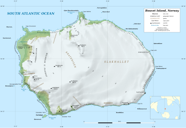
Deutsch: Topografische Karte von Bouvetinsel
English: Topographic map in English of Bouvet Island
Français : Carte topographique en anglais de l’île Bouvet. Scale: 1:80,000 (precision: 20 m for the topography and ground features)
|
||
| Dagur | |||
| Kelda |
data:
|
||
| Høvundur | Eric Gaba (Sting - fr:Sting) | ||
| Loyvi (Endurnýtsla av hesi fílu) |
|
||
| Other versions |
[]
|


Lisensur
I, the copyright holder of this work, hereby publish it under the following license:
This file is licensed under the Creative Commons Attribution-Share Alike 4.0 International license.
- Tú ert vælkomin til:
- at deila – at avrita, breiða út og senda verkið
- at remiksa – at tillaga ella broyta verkið
- Undir hesum treytum:
- ognan – Tú mást ognarskrivað verkið á ein slíkan hátt sum er útgreinaður av høvundanum ella lisenseigaranum (men ikki á nakran hátt ið kundi bent á at hesin hevur góðkent teg ella tína nýtslu av verkinum).
- deil undir somu treytum – Um tú broytir, evnar til ella byggir víðari á hetta verk, so kanst tú bert útgeva verkið undir somu ella líkandi lisensi sum hesin.
Søgan hjá fíluni
Trýst á dato/tíð fyri at síggja fíluna, sum hon sá út tá.
| Dagur/Tíð | Lítil mynd | Dimensjónir | Brúkari | Viðmerking | |
|---|---|---|---|---|---|
| streymur | 17. apr 2022 kl. 15:05 | | 2.800 × 1.926 (1,13 MB) | Sting | Display correction on locator map |
| 23. feb 2020 kl. 18:21 |  | 2.800 × 1.926 (1,13 MB) | Sting | Display problems for some texts | |
| 22. feb 2020 kl. 18:01 |  | 2.800 × 1.926 (887 KB) | Sting | == {{int:filedesc}} == {{Location|54|25|00|S|003|21|00|E|scale:100000}} {{Information |Description= {{de|Topografische Karte von Bouvetinsel}} {{en|Topographic map in English of Bouvet Island}} {{fr|Carte topographique en anglais de l’île Bouvet.}}<br/> Scale: 1:80,000 (precision: 20 m for the topography and ground features)<br/> Equirectangular projection, WGS84 datum<br/> *Central parallel: 54.41995° S<br/> |Source=data:<br/> *[h... |
Myndarslóðir
Hesar síður slóða til hesa mynd:
Alheims fílunýtsla
Aðrar wkiir brúka hesa fílu:
- Nýtsla á de.wikipedia.org
- Bouvetinsel
- Kap Valdivia
- Kap Lollo
- Gjest Baardsenstøtta
- Bennskjera
- Norvegiaodden
- Bollevika
- Catoodden
- Larsøya
- Horn-Riff
- Litle-Kari
- Store-Kari
- Lindsayskjeret
- Kap Meteor
- Norris-Riff
- Norvegiabåen
- Rustadkollen
- Spiessbåane
- Williams-Riff
- Mottesundet
- Djevleporten
- Svarthamaren (Bouvetinsel)
- Nyrøysa
- Ole Høilandstøtta
- Nyknausen
- Randibåen
- Selodden
- Skarven (Insel)
- Randtoppen
- Wilhelm-II.-Plateau
- Keisarryggen
- Skoddenuten
- Mosbytoppane
- Eimstupet
- Mokollen
- Moseryggen
- Nýtsla á en.wikipedia.org
- Nýtsla á es.wikipedia.org
- Nýtsla á ja.wikipedia.org
Vís meiri globala nýtslu av hesi fílu.