Mynd:Vatican City map EN.png

Stødd av hesi forskoðan: 777 × 600 pixels. Aðrar upploysnir: 311 × 240 pixels | 622 × 480 pixels | 995 × 768 pixels | 1.280 × 988 pixels | 2.560 × 1.977 pixels | 2.888 × 2.230 pixels.
Upprunafíla (2.888 × 2.230 pixel, stødd fílu: 2,41 MB, MIME-slag: image/png)
Samandráttur
| Description |
Deutsch: Karte der Vatikanstadt (englische Version)
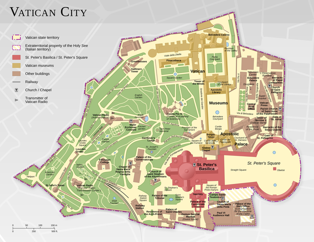
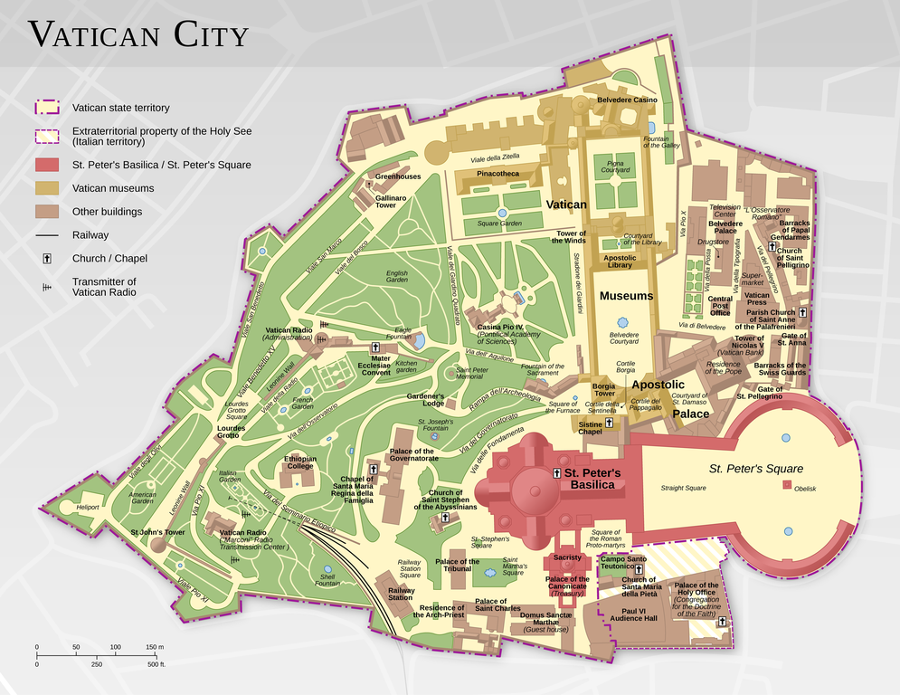
English: Map of the Vatican City (English version)
Español: Mapa de la Ciudad del Vaticano (versión en inglés).
Suomi: Vatikaanin kartta (englanninkielinen versio)
Français : Carte de la Cité du Vatican, à partir d'informations d'OpenStreetMap. Version en anglais ; voir la version en français ici : Vatican City map FR.png
中文:梵蒂冈城国地图(英语版本)
Bosanski: Karta Vatikana - sadrži kartografske podatke sa projekta ©OpenStreetMap (ODbL).
|
|||||||||
| Dagur | ||||||||||
| Kelda |
Egið verk |
|||||||||
| Skapari | ||||||||||
| Loyvi (Endurnýtsla av hesi fílu) |
|
|||||||||
| Geotemporal data | ||||||||||
| Bounding box |
|
|||||||||
| Georeferencing | ||||||||||
| Other versions |
|
|||||||||


|
This map has been made or improved in the German Kartenwerkstatt (Map Lab). You can propose maps to improve as well.
|
Lisensur
Henda fíla er gjørd atkomulig undir Creative Commons Navngev-Deil á sama hátt 3.0 Unported loyvinum.
Ognan: Thomas Römer/OpenStreetMap data
- Tú ert vælkomin til:
- at deila – at avrita, breiða út og senda verkið
- at remiksa – at tillaga ella broyta verkið
- Undir hesum treytum:
- ognan – Tú mást ognarskrivað verkið á ein slíkan hátt sum er útgreinaður av høvundanum ella lisenseigaranum (men ikki á nakran hátt ið kundi bent á at hesin hevur góðkent teg ella tína nýtslu av verkinum).
- deil undir somu treytum – Um tú broytir, evnar til ella byggir víðari á hetta verk, so kanst tú bert útgeva verkið undir somu ella líkandi lisensi sum hesin.
Assessment
|

This image was selected as picture of the day on Wikimedia Commons for 11 February 2015. It was captioned as follows: Other languages:
Bosanski: Karta Vatikana - sadrži kartografske podatke sa projekta ©OpenStreetMap (ODbL). |
Søgan hjá fíluni
Trýst á dato/tíð fyri at síggja fíluna, sum hon sá út tá.
| Dagur/Tíð | Lítil mynd | Dimensjónir | Brúkari | Viðmerking | |
|---|---|---|---|---|---|
| streymur | 12. feb 2021 kl. 11:44 | | 2.888 × 2.230 (2,41 MB) | Foghe | St. Damasco → St. Damaso. |
| 11. apr 2013 kl. 09:22 |  | 2.888 × 2.230 (2,14 MB) | Thoroe | larger render | |
| 10. apr 2013 kl. 17:12 |  | 1.733 × 1.338 (1,11 MB) | Thoroe | small fixes | |
| 23. mar 2013 kl. 15:59 |  | 1.733 × 1.338 (1,1 MB) | Thoroe | minor fixes | |
| 23. mar 2013 kl. 00:41 |  | 1.733 × 1.338 (1,09 MB) | Thoroe | {{Information |Description ={{en|1=Map of the Vatican City (English version)}} {{de|1=Karte der Vatikanstadt (englische Version)}} |Source ={{own}} *[http://www.vatican.va/news_services/press/docume... |
Myndarslóðir
Hesar síður slóða til hesa mynd:
Alheims fílunýtsla
Aðrar wkiir brúka hesa fílu:
- Nýtsla á af.wikipedia.org
- Nýtsla á be-tarask.wikipedia.org
- Nýtsla á ca.wikipedia.org
- Nýtsla á crh.wikipedia.org
- Nýtsla á cv.wikipedia.org
- Nýtsla á de.wikipedia.org
- Nýtsla á en.wikipedia.org
- Wikipedia:Featured pictures/Diagrams, drawings, and maps/Maps
- Talk:Vatican City/Archive 1
- User talk:Thoroe
- Wikipedia:Featured pictures thumbs/37
- User talk:Crisco 1492/Archive 44
- Wikipedia:Featured picture candidates/Vatican City map
- Wikipedia:Featured picture candidates/October-2013
- Wikipedia:Picture of the day/August 2015
- Template:POTD/2015-08-07
- Wikipedia:Main Page history/2015 August 7
- User:John Paul II/Line of Popes
- Portal:Geography/Selected picture
- User:ਕਰਨ 13/sandbox
- Nýtsla á en.wikivoyage.org
- Nýtsla á fr.wikipedia.org
- Nýtsla á hu.wikipedia.org
- Nýtsla á ka.wikipedia.org
- Nýtsla á ko.wikipedia.org
- Nýtsla á krc.wikipedia.org
- Nýtsla á lbe.wikipedia.org
- Nýtsla á www.mediawiki.org
- Nýtsla á mg.wikipedia.org
- Nýtsla á os.wikipedia.org
- Nýtsla á pl.wikipedia.org
- Nýtsla á pt.wikipedia.org
- Nýtsla á ru.wikipedia.org
- Nýtsla á ru.wikinews.org
- Nýtsla á sah.wikipedia.org
- Nýtsla á sv.wikipedia.org
- Nýtsla á tr.wikipedia.org
- Nýtsla á tt.wikipedia.org
- Nýtsla á uk.wikipedia.org
Vís meiri globala nýtslu av hesi fílu.