Mynd:Uluru (Helicopter view)-crop.jpg

Stødd av hesi forskoðan: 799 × 376 pixels. Aðrar upploysnir: 320 × 151 pixels | 640 × 301 pixels | 1.024 × 482 pixels | 2.025 × 953 pixels.
Upprunafíla (2.025 × 953 pixel, stødd fílu: 1,83 MB, MIME-slag: image/jpeg)
-crop.jpg)
Samandráttur
| Frágreiðing |
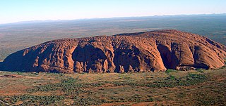
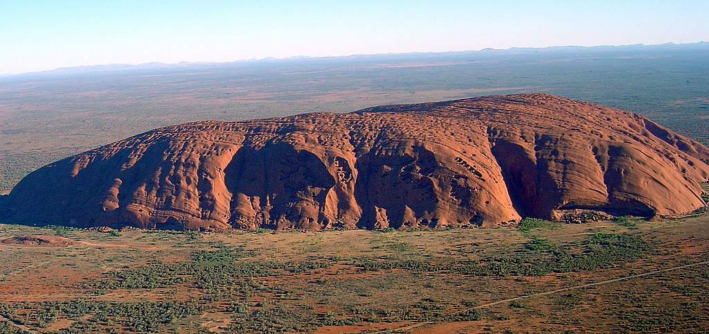
English: Helicopter view of Uluru/Ayers Rock. Cropped and colours enhanced for use in Infobox. |
| Dagur | |
| Kelda | Modification of Image:Uluru (Helicopter view).jpg |
| Høvundur | User:Huntster |
| Loyvi (Endurnýtsla av hesi fílu) |
Public domain |
| Other versions |
.jpg) |
| Camera location | | View this and other nearby images on: OpenStreetMap |
|---|
-crop.jpg¶ms=-25.348889_N_0131.036389_E_globe:Earth_type:camera__&language=fo)
Lisensur
| I, the copyright holder of this work, release this work into the public domain. This applies worldwide. In some countries this may not be legally possible; if so: I grant anyone the right to use this work for any purpose, without any conditions, unless such conditions are required by law. |
Søgan hjá fíluni
Trýst á dato/tíð fyri at síggja fíluna, sum hon sá út tá.
| Dagur/Tíð | Lítil mynd | Dimensjónir | Brúkari | Viðmerking | |
|---|---|---|---|---|---|
| streymur | 1. des 2008 kl. 18:54 | | 2.025 × 953 (1,83 MB) | Huntster | == Summary == {{Information |Description={{en|Helicopter view of Uluru. Cropped and colours enhanced for use in Infobox.}} |Source=Modification of Image:Uluru (Helicopter view).jpg |Date=2008-12-01 |Author=User:Huntster |Permission=Public domain |
.jpg)
Myndarslóðir
Hesar síður slóða til hesa mynd:
Alheims fílunýtsla
Aðrar wkiir brúka hesa fílu:
- Nýtsla á arz.wikipedia.org
- Nýtsla á az.wikipedia.org
- Nýtsla á cy.wikipedia.org
- Nýtsla á de.wikipedia.org
- Nýtsla á en.wikipedia.org
- List of mountains in Australia
- Goat Paddock crater
- Geological formation
- Canning Basin
- Mount Murray (New South Wales)
- Windimurra intrusion
- Centralian Superbasin
- Kenn Plateau
- Amadeus Basin
- Georgina Basin
- Ngalia Basin
- McArthur Basin
- Glikson crater
- Gnangara Mound
- Darling Fault
- Collie Sub-basin
- Dinosaur Dreaming
- Norfolk Ridge
- Mount Fitch (Northern Territory)
- Ayers Rock (band)
- Lochend Colliery
- Lake Macquarie Petrified Forest
- Wallabi Limestone
- Jeebropilly Mine
- Carnarvon Basin
- Sublime Point
- Shell House
- Pencell Pool
- Template:Australia-geology-stub
- Australian Fossil Mammal Sites (Riversleigh / Naracoorte)
- User:Sussexonian/Maps
- Goonyella Riverside Mine
- Jandakot Mound
- Mittagong Formation
- User:Cruickshanks/Sandbox
- Grenfell fossil site
- Lake Ngapakaldi to Lake Palankarinna Fossil Area
- Myuna Colliery
- Chain Valley Colliery
- Wallarah Colliery
- Yea Flora Fossil Site
- User talk:Tobyc75/Archive 1
- Westside Mine
- Illawarra Coal Measures
- Nowra Sandstone
Vís meiri globala nýtslu av hesi fílu.
-crop.jpg)
-crop.jpg)