Mynd:Tour de France 2015 map-fr.svg

Size of this PNG preview of this SVG file: 498 × 600 pixels. Aðrar upploysnir: 199 × 240 pixels | 399 × 480 pixels | 638 × 768 pixels | 850 × 1.024 pixels | 1.701 × 2.048 pixels | 1.225 × 1.475 pixels.
Upprunafíla (SVG fíle, nominelt 1.225 × 1.475 pixel, fíle stødd: 1,85 MB)
Samandráttur
| Frágreiðing |
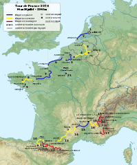
English: Roadmap of Tour de France 2015. Français : Carte du tracé du Tour de France 2015. |
||
| Dagur | |||
| Kelda |
|
||
| Høvundur | Sémhur (kjak) | ||
| Other versions |
| ||
| Ognan (required by the license) | © Sémhur / Wikimedia Commons / | ||
| SVG | W3C-validity not checked.
|
||
| Graphic Lab |

| Object location | | View this and other nearby images on: OpenStreetMap |
|---|
Lisensur
I, the copyright holder of this work, hereby publish it under the following licenses:
| Copyleft: This work of art is free; you can redistribute it and/or modify it according to terms of the Free Art License. You will find a specimen of this license on the Copyleft Attitude site as well as on other sites. |
This file is licensed under the Creative Commons Attribution-Share Alike 4.0 International, 3.0 Unported, 2.5 Generic, 2.0 Generic and 1.0 Generic license.
- Tú ert vælkomin til:
- at deila – at avrita, breiða út og senda verkið
- at remiksa – at tillaga ella broyta verkið
- Undir hesum treytum:
- ognan – Tú mást ognarskrivað verkið á ein slíkan hátt sum er útgreinaður av høvundanum ella lisenseigaranum (men ikki á nakran hátt ið kundi bent á at hesin hevur góðkent teg ella tína nýtslu av verkinum).
- deil undir somu treytum – Um tú broytir, evnar til ella byggir víðari á hetta verk, so kanst tú bert útgeva verkið undir somu ella líkandi lisensi sum hesin.
Tú kanst velja tann lisens ið tú ynskir.
Søgan hjá fíluni
Trýst á dato/tíð fyri at síggja fíluna, sum hon sá út tá.
| Dagur/Tíð | Lítil mynd | Dimensjónir | Brúkari | Viðmerking | |
|---|---|---|---|---|---|
| streymur | 12. aug 2015 kl. 18:33 | | 1.225 × 1.475 (1,85 MB) | Sémhur | L'étape 4 est en accidentée (et non plus plaine), l'étape 10 aussi en accidentée (et non montagne) et l’étape 13 encore en accidentée (et non en plaine). Cf. page 12 du règlement (http://www.letour.fr/le-tour/2015/docs/TDF15_Reglement-BD.pdf) |
| 19. jul 2015 kl. 09:55 |  | 1.225 × 1.475 (1,85 MB) | Sémhur | 17 => 20 | |
| 8. apr 2015 kl. 20:53 |  | 1.225 × 1.475 (1,85 MB) | Sémhur | == {{int:filedesc}} == {{Information |Description={{Multilingual description |en= Roadmap of Tour de France 2015. |fr= Carte du tracé du Tour de France 2015. }} |Source= * [[:File:Fond de carte T... |
Myndarslóðir
Ongar síður slóða til hesa myndina.
Alheims fílunýtsla
Aðrar wkiir brúka hesa fílu:
- Nýtsla á cy.wikipedia.org
- Nýtsla á de.wikipedia.org
- Nýtsla á fi.wikipedia.org
- Nýtsla á fr.wikipedia.org
- Nýtsla á hr.wikipedia.org
- Nýtsla á ie.wikipedia.org
- Nýtsla á it.wikipedia.org
- Nýtsla á ja.wikipedia.org
- Nýtsla á nl.wikipedia.org
- Nýtsla á sv.wikipedia.org