Mynd:Topographic-Relief-perspective-sample.jpg
Ongin hægri upploysn varð funnin.
Topographic-Relief-perspective-sample.jpg (796 × 468 pixel, stødd fílu: 97 KB, MIME-slag: image/jpeg)
Samandráttur
| Frágreiðing |
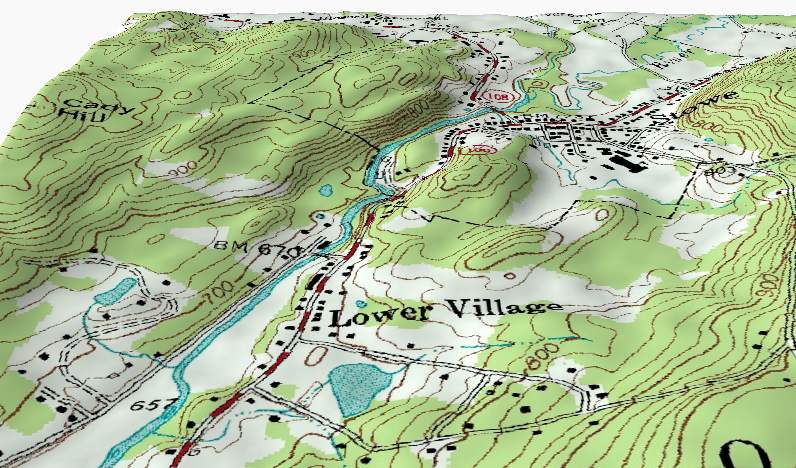
English: A perspective shaded-relief view of part of a topographic map sample. This perspective view illustrates how the contour lines on a Topographic map describe terrain by following the shape of the land at a constant elevation. Note: The vertical relief in this view has been exaggerated. |
| Dagur | 11 august 2004 (original upload date) |
| Kelda | Transferred from en.wikipedia to Commons. Derived from from USGS data files o44072d6.tif and 1631103.dem.sdts.tar.gz. |
| Høvundur | Kbh3rd at enskt Wikipedia |
Lisensur
Kbh3rd, the copyright holder of this work, hereby publishes it under the following licenses:
This file is licensed under the Creative Commons Attribution-Share Alike 2.0 Generic license.
Ognan: Kbh3rd
- Tú ert vælkomin til:
- at deila – at avrita, breiða út og senda verkið
- at remiksa – at tillaga ella broyta verkið
- Undir hesum treytum:
- ognan – Tú mást ognarskrivað verkið á ein slíkan hátt sum er útgreinaður av høvundanum ella lisenseigaranum (men ikki á nakran hátt ið kundi bent á at hesin hevur góðkent teg ella tína nýtslu av verkinum).
- deil undir somu treytum – Um tú broytir, evnar til ella byggir víðari á hetta verk, so kanst tú bert útgeva verkið undir somu ella líkandi lisensi sum hesin.
| Henda fíla er gjørd atkomulig undir Creative Commons Navngev-Deil á sama hátt 3.0 Unported loyvinum. Subject to disclaimers. | ||
| Ognan: Kbh3rd | ||
| ||
| This licensing tag was added to this file as part of the GFDL licensing update. |

|
Loyvi verður givi at avrita, bera út og/ella broyta hetta skjal undir treytunum hjá GNU Free Documentation License, versión 1.2 ella einhvør seinni versjón ið er útgivin av Free Software Foundation; uttan nakað óbroytiligt brot, uttan forsíðutekst og uttan baksíðutekst. Eitt avrit av loyvinum er tikið við í brotinum ið nevnist GNU Free Documentation License. Subject to disclaimers. |
Tú kanst velja tann lisens ið tú ynskir.
Original upload log
The original description page was here. All following user names refer to en.wikipedia.
- 2004-08-11 04:23 Kbh3rd 796×468× (99279 bytes) Shaded relief perspective view of topographic map sample
Søgan hjá fíluni
Trýst á dato/tíð fyri at síggja fíluna, sum hon sá út tá.
| Dagur/Tíð | Lítil mynd | Dimensjónir | Brúkari | Viðmerking | |
|---|---|---|---|---|---|
| streymur | 3. feb 2011 kl. 19:53 | | 796 × 468 (97 KB) | File Upload Bot (Magnus Manske) | {{BotMoveToCommons|en.wikipedia|year={{subst:CURRENTYEAR}}|month={{subst:CURRENTMONTHNAME}}|day={{subst:CURRENTDAY}}}} {{Information |Description={{en|'''Description''': A perspective shaded-relief view of part of a [[:en:Media:Topographic_map_example.pn |
Myndarslóðir
Hesar síður slóða til hesa mynd:
Alheims fílunýtsla
Aðrar wkiir brúka hesa fílu:
- Nýtsla á bn.wikipedia.org
- Nýtsla á en.wikipedia.org
- Nýtsla á fa.wikipedia.org
- Nýtsla á fr.wikipedia.org
- Nýtsla á ja.wikipedia.org
- Nýtsla á ml.wikipedia.org
- Nýtsla á pt.wikipedia.org
- Nýtsla á vi.wikipedia.org