Mynd:Slovakia1941 02.png
Stødd av hesi forskoðan: 794 × 600 pixels. Aðrar upploysnir: 318 × 240 pixels | 636 × 480 pixels | 997 × 753 pixels.
Upprunafíla (997 × 753 pixel, stødd fílu: 50 KB, MIME-slag: image/png)
Samandráttur
| Frágreiðing |
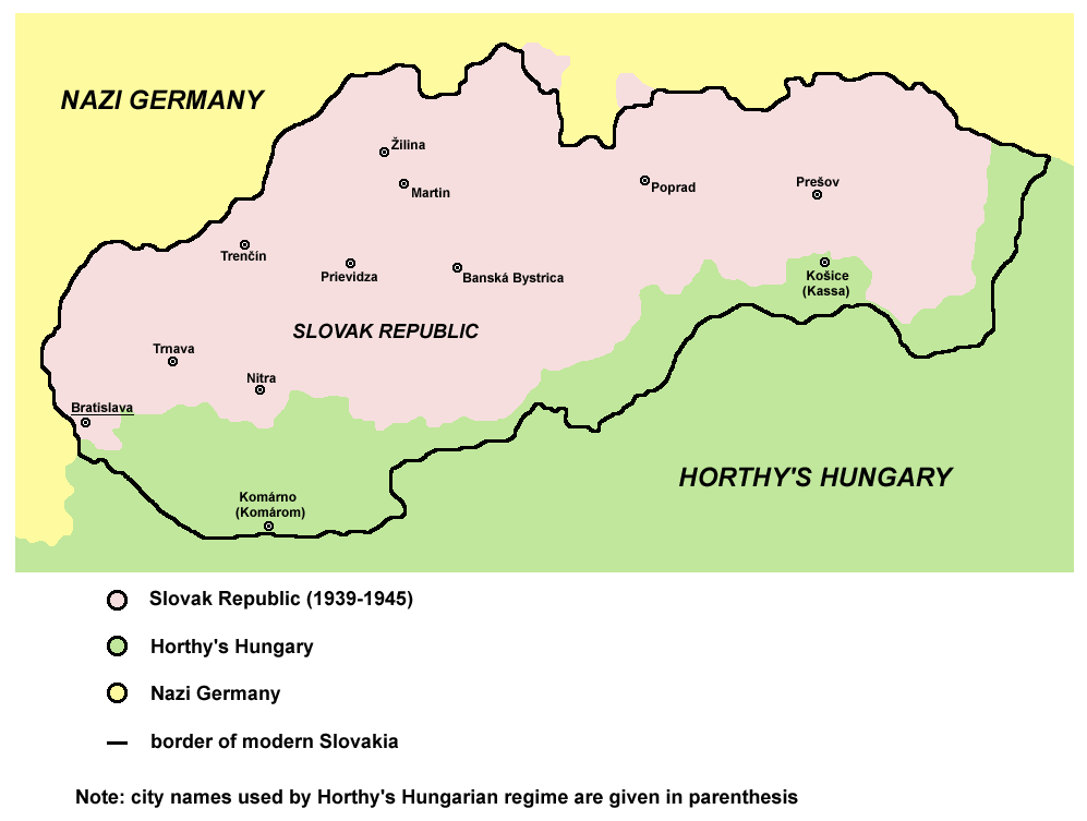
English: historic map of Slovak Republic (1939-1945) |
| Dagur | 28 desember 2006 (original upload date) |
| Kelda | Egið verk |
| Høvundur | PANONIAN |
| Other versions |
[]
|


.png)

References
Published references:
- The Times History of Europe, Times Books, London, 2002.
- Richard Overy, The Times History of the 20th Century, Times Books, London, 2003.
- Istorijski atlas, Zavod za udžbenike i nastavna sredstva - Zavod za kartografiju "Geokarta", Beograd, 1999.
- Peter Rokai - Zoltan Đere - Tibor Pal - Aleksandar Kasaš, Istorija Mađara, Beograd, 2002.
Internet references:
Lisensur
self made map by user:PANONIAN

|
This map has been uploaded by Electionworld from en.wikipedia.org to enable the |
| I, the copyright holder of this work, release this work into the public domain. This applies worldwide. In some countries this may not be legally possible; if so: I grant anyone the right to use this work for any purpose, without any conditions, unless such conditions are required by law. |
derivative works
Derivative works of this file:
Søgan hjá fíluni
Trýst á dato/tíð fyri at síggja fíluna, sum hon sá út tá.
| Dagur/Tíð | Lítil mynd | Dimensjónir | Brúkari | Viðmerking | |
|---|---|---|---|---|---|
| streymur | 29. apr 2011 kl. 09:43 | | 997 × 753 (50 KB) | Piastu | Reverted to version as of 10:58, 5 March 2011 |
| 29. apr 2011 kl. 09:33 |  | 794 × 600 (95 KB) | Damianwiszowaty12 | Translate words in picture. | |
| 5. mar 2011 kl. 10:58 |  | 997 × 753 (50 KB) | PANONIAN | aesthetical correction | |
| 22. aug 2009 kl. 17:04 |  | 997 × 753 (50 KB) | PANONIAN | ||
| 22. aug 2009 kl. 14:02 |  | 997 × 662 (46 KB) | PANONIAN | ||
| 28. des 2006 kl. 16:25 |  | 773 × 448 (8 KB) | Electionworld | {{ew|en|PANONIAN}} historic map of Slovakia (self made) {{PD-self}} Category:Maps of the history of Slovakia Category:Maps of World War II in Europe |
Myndarslóðir
Hesar síður slóða til hesa mynd:
Alheims fílunýtsla
Aðrar wkiir brúka hesa fílu:
- Nýtsla á an.wikipedia.org
- Nýtsla á azb.wikipedia.org
- Nýtsla á be-tarask.wikipedia.org
- Nýtsla á be.wikipedia.org
- Nýtsla á bg.wikipedia.org
- Nýtsla á bs.wikipedia.org
- Nýtsla á ca.wikipedia.org
- Nýtsla á cs.wikipedia.org
- Nýtsla á cv.wikipedia.org
- Nýtsla á da.wikipedia.org
- Nýtsla á de.wikipedia.org
- Nýtsla á el.wikipedia.org
- Nýtsla á en.wikipedia.org
- Nýtsla á eo.wikipedia.org
- Nýtsla á et.wikipedia.org
- Nýtsla á fa.wikipedia.org
- Nýtsla á fr.wikipedia.org
- Nýtsla á he.wikipedia.org
- Nýtsla á hr.wikipedia.org
- Nýtsla á hu.wikipedia.org
- Nýtsla á id.wikipedia.org
- Nýtsla á is.wikipedia.org
- Nýtsla á it.wikipedia.org
- Nýtsla á ja.wikipedia.org
- Nýtsla á jv.wikipedia.org
- Nýtsla á ko.wikipedia.org
- Nýtsla á lt.wikipedia.org
- Nýtsla á nl.wikipedia.org
- Nýtsla á no.wikipedia.org
- Nýtsla á pl.wikipedia.org
- Nýtsla á pt.wikipedia.org
- Nýtsla á ro.wikipedia.org
Vís meiri globala nýtslu av hesi fílu.