Mynd:Shetlandinseln (Landsat).jpg

Upprunafíla (2.986 × 2.986 pixel, stødd fílu: 7,35 MB, MIME-slag: image/jpeg)
.jpg)
- Svenska: Satellitbild av Shetlandsöarna
- English: Satellite image of the Shetland Islands.
| This file is in the public domain in the United States because it was solely created by NASA. NASA copyright policy states that "NASA material is not protected by copyright unless noted". (See Template:PD-USGov, NASA copyright policy page or JPL Image Use Policy.) | ||
 |
Warnings:
|
From the German Wikipedia
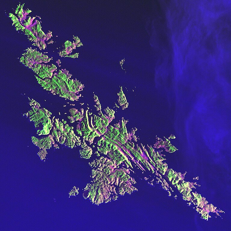
Earth As Art: Shetlandinseln (Landsat)
von: http://landsat.gsfc.nasa.gov/earthasart/shetland.html
Public Domain, Image courtesy of NASA Landsat Project Science Office and USGS EROS Data Center
Shetland Islands Image taken 12/11/2001 by Landsat 7
Like a many-faceted jewel fashioned in an indigo setting, the Shetland Islands lie 210 kilometers north of the Scottish mainland in the North Atlantic Ocean. Despite their 60 degree north latitude, the Shetlands enjoy a relatively temperate climate thanks to the warming influence of the Gulf Stream.
This image can be found on Landsat 7 Path 205 Row 18, center: 60.1 N, 1.2 W.
Bild-Versionen
Legende: (Aktuell) = dies ist das aktuelle Bild, (Löschen) = lösche diese alte Version, (Zurücksetzen) = verwende wieder diese alte Version.
- (Löschen) (Aktuell) 20:40, 30. Mär 2004 . . Srbauer (23305 Byte) (Earth As Art: Shetlandinseln (Landsat))
Søgan hjá fíluni
Trýst á dato/tíð fyri at síggja fíluna, sum hon sá út tá.
| Dagur/Tíð | Lítil mynd | Dimensjónir | Brúkari | Viðmerking | |
|---|---|---|---|---|---|
| streymur | 10. feb 2010 kl. 00:01 | | 2.986 × 2.986 (7,35 MB) | Scewing | Higher Resolution |
| 19. jun 2005 kl. 22:57 |  | 287 × 287 (23 KB) | Laserpekare~commonswiki |
Myndarslóðir
Hesar síður slóða til hesa mynd:
Alheims fílunýtsla
Aðrar wkiir brúka hesa fílu:
- Nýtsla á af.wikipedia.org
- Nýtsla á da.wikipedia.org
- Nýtsla á de.wikipedia.org
- Nýtsla á fr.wikipedia.org
- Nýtsla á la.wikipedia.org
- Nýtsla á pl.wikipedia.org
- Nýtsla á pl.wiktionary.org
.jpg)