Mynd:Scottish infobox template map.png

Stødd av hesi forskoðan: 451 × 600 pixels. Aðrar upploysnir: 180 × 240 pixels | 361 × 480 pixels | 577 × 768 pixels | 1.154 × 1.535 pixels.
Upprunafíla (1.154 × 1.535 pixel, stødd fílu: 661 KB, MIME-slag: image/png)
Samandráttur
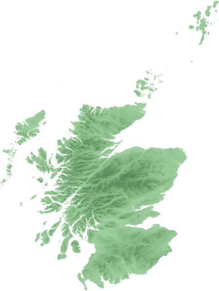
| Frágreiðing | Topo map of Scotland for use in Scottish infoboxes - equidistant cylindrical projection as naturaly outputted from SRTM data, stretched 150% vertically as deduced by w:User:Anameofmyveryown for easier viewing. |
| Dagur | |
| Kelda | SRTM data from NASA, PD |
| Høvundur | SFC9394 |
Lisensur

|
Loyvi verður givi at avrita, bera út og/ella broyta hetta skjal undir treytunum hjá GNU Free Documentation License, versión 1.2 ella einhvør seinni versjón ið er útgivin av Free Software Foundation; uttan nakað óbroytiligt brot, uttan forsíðutekst og uttan baksíðutekst. Eitt avrit av loyvinum er tikið við í brotinum ið nevnist GNU Free Documentation License. |
| Henda fíla er gjørd atkomulig undir Creative Commons Navngev-Deil á sama hátt 3.0 Unported loyvinum. | ||
| ||
| This licensing tag was added to this file as part of the GFDL licensing update. |
Søgan hjá fíluni
Trýst á dato/tíð fyri at síggja fíluna, sum hon sá út tá.
| Dagur/Tíð | Lítil mynd | Dimensjónir | Brúkari | Viðmerking | |
|---|---|---|---|---|---|
| streymur | 21. sep 2007 kl. 22:48 | | 1.154 × 1.535 (661 KB) | SFC9394 | {{Information |Description=Topo map of Scotland for use in Scottish infoboxes - equidistant cylindrical projection as naturaly outputted from SRTM data, stretched 150% vertically as deduced by w:User:Anameofmyveryown for easier viewing. |Source=SRTM d |
Myndarslóðir
Hesar síður slóða til hesa mynd:
Alheims fílunýtsla
Aðrar wkiir brúka hesa fílu:
- Nýtsla á am.wikipedia.org
- Nýtsla á as.wikipedia.org
- Nýtsla á awa.wikipedia.org
- Nýtsla á azb.wikipedia.org
- Nýtsla á bn.wikipedia.org
- Nýtsla á da.wikipedia.org
- Nýtsla á diq.wikipedia.org
- Nýtsla á en.wikipedia.org
- User talk:SFC9394
- Wikipedia talk:WikiProject Scotland/Archive 6
- Template:Location mark+
- Template:Location mark+/doc
- Template:Location mark+/testcases
- Template:Location mark
- Template:Location mark/doc
- Template:Location mark~/testcases
- Template:Location mark+/sandbox
- Template:Location mark/sandbox
- Template:Location mark label
- Nýtsla á en.wikiversity.org
- Nýtsla á fa.wikipedia.org
- Nýtsla á fr.wikipedia.org
- Nýtsla á gv.wikipedia.org
- Nýtsla á hi.wikipedia.org
- Nýtsla á hy.wikipedia.org
Vís meiri globala nýtslu av hesi fílu.