Mynd:Scotland map-en.svg

Size of this PNG preview of this SVG file: 417 × 599 pixels. Aðrar upploysnir: 167 × 240 pixels | 334 × 480 pixels | 534 × 768 pixels | 712 × 1.024 pixels | 1.425 × 2.048 pixels | 2.400 × 3.450 pixels.
Upprunafíla (SVG fíle, nominelt 2.400 × 3.450 pixel, fíle stødd: 4,35 MB)
Samandráttur
| Camera location | | View this and other nearby images on: OpenStreetMap |
|---|
| Frágreiðing |
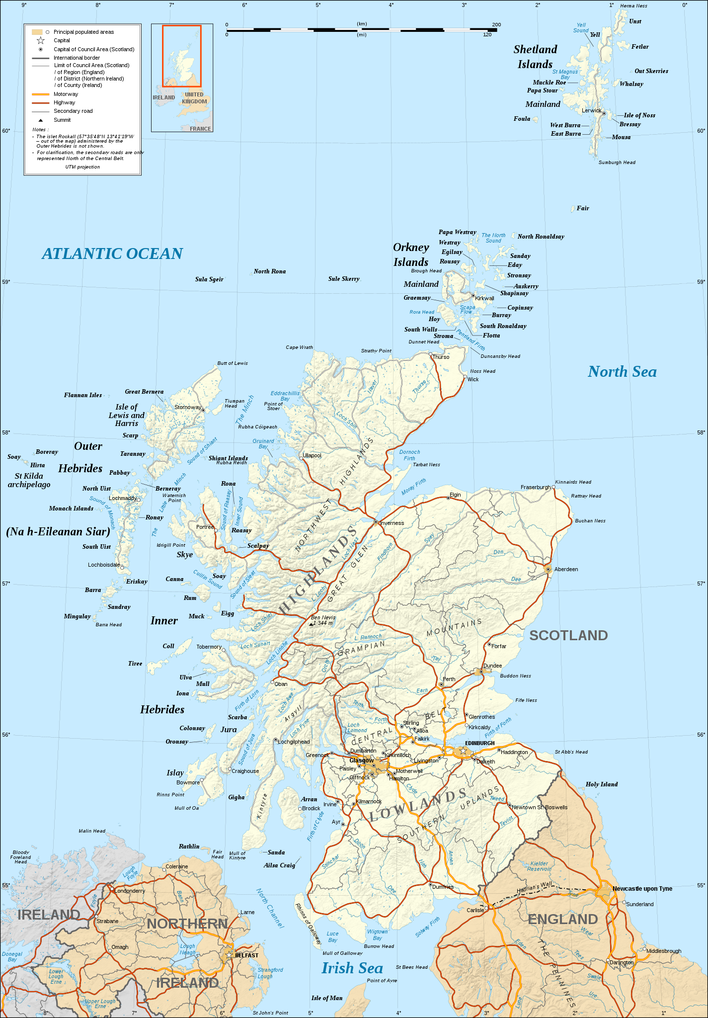
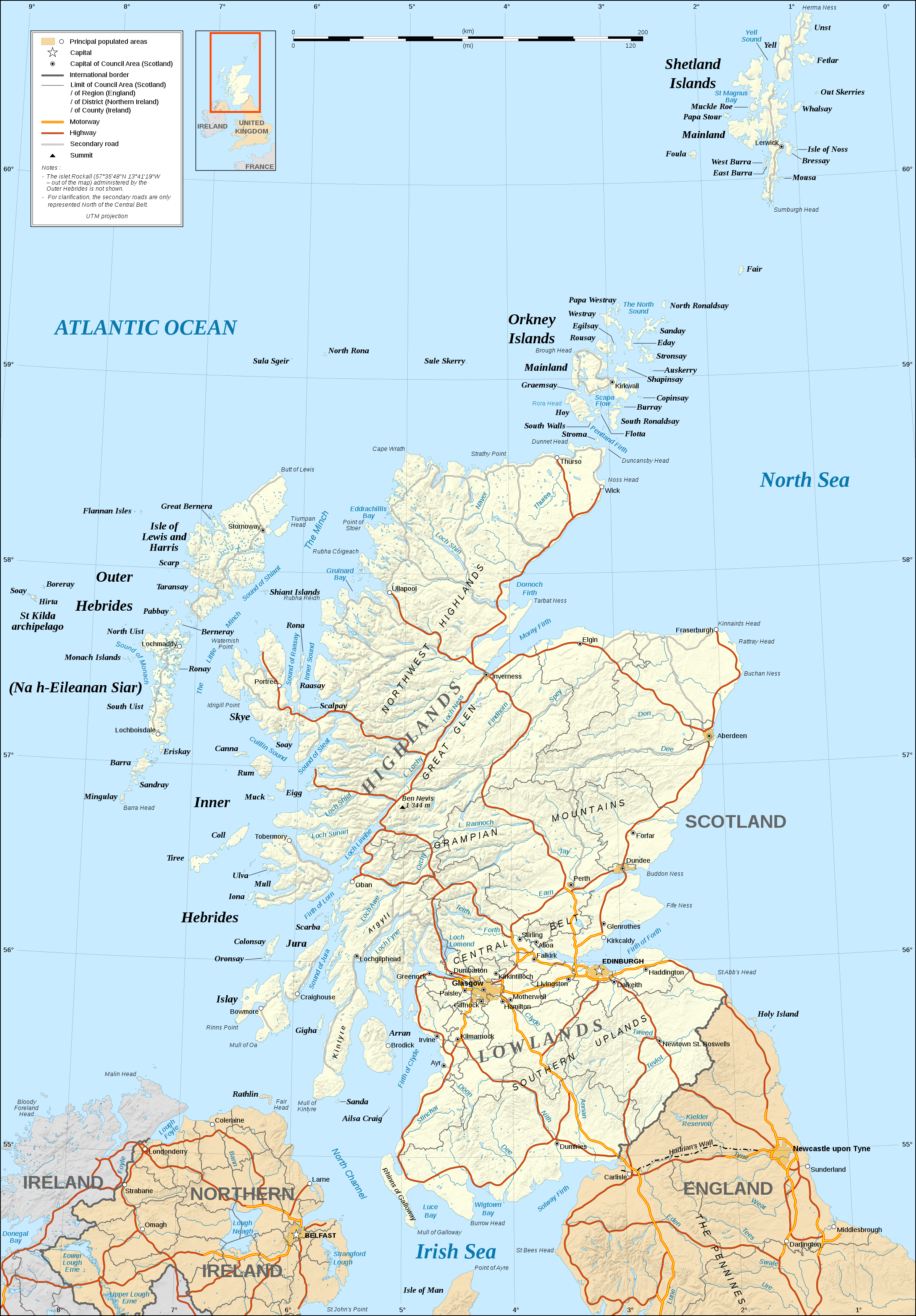
English: Map in English of Scotland.
Note: The shaded relief is a raster image embedded in the SVG file. Français : Carte en anglais de l'Écosse.
Note : Le relief ombré est une image bitmap embarquée dans le fichier SVG. Approximate scales: 1:3,000,000 (accuracy : about 750 m) until 60.38° and 1:4,000,000 (accuracy : about 1,000 m) North of 60.38° |
||
| Dagur | |||
| Kelda |
Own work ;
|
||
| Høvundur | Eric Gaba (Sting - fr:Sting) | ||
| Loyvi (Endurnýtsla av hesi fílu) |
|
||
| Other versions |
Derivative works of this file: ScotlandMoray.svg
[]
|


|
This SVG file contains embedded text that can be translated into your language, using any capable SVG editor, text editor or the SVG Translate tool. For more information see: About translating SVG files. |
Lisensur
I, the copyright holder of this work, hereby publish it under the following licenses:

|
Loyvi verður givi at avrita, bera út og/ella broyta hetta skjal undir treytunum hjá GNU Free Documentation License, versión 1.2 ella einhvør seinni versjón ið er útgivin av Free Software Foundation; uttan nakað óbroytiligt brot, uttan forsíðutekst og uttan baksíðutekst. Eitt avrit av loyvinum er tikið við í brotinum ið nevnist GNU Free Documentation License. |
This file is licensed under the Creative Commons Attribution-Share Alike 4.0 International, 3.0 Unported, 2.5 Generic, 2.0 Generic and 1.0 Generic license.
- Tú ert vælkomin til:
- at deila – at avrita, breiða út og senda verkið
- at remiksa – at tillaga ella broyta verkið
- Undir hesum treytum:
- ognan – Tú mást ognarskrivað verkið á ein slíkan hátt sum er útgreinaður av høvundanum ella lisenseigaranum (men ikki á nakran hátt ið kundi bent á at hesin hevur góðkent teg ella tína nýtslu av verkinum).
- deil undir somu treytum – Um tú broytir, evnar til ella byggir víðari á hetta verk, so kanst tú bert útgeva verkið undir somu ella líkandi lisensi sum hesin.
Tú kanst velja tann lisens ið tú ynskir.
Søgan hjá fíluni
Trýst á dato/tíð fyri at síggja fíluna, sum hon sá út tá.
| Dagur/Tíð | Lítil mynd | Dimensjónir | Brúkari | Viðmerking | |
|---|---|---|---|---|---|
| streymur | 17. jun 2008 kl. 21:31 | | 2.400 × 3.450 (4,35 MB) | Sting | Colors modified |
| 14. des 2007 kl. 01:14 |  | 2.400 × 3.450 (4,36 MB) | Sting | Additional name | |
| 13. des 2007 kl. 19:19 |  | 2.400 × 3.450 (4,36 MB) | Sting | {{Location|57|00|00|N|04|00|00|W|scale:4000000}} <br/> {{Information |Description=Map in English of Scotland |Source=Own work ;<br/>Shore / lakes contours and shaded relief : [http://www2.jpl.nasa.gov/srtm NASA Shuttle Radar Topography Mi |
Myndarslóðir
Ongar síður slóða til hesa myndina.
Alheims fílunýtsla
Aðrar wkiir brúka hesa fílu:
- Nýtsla á hu.wikipedia.org