Mynd:Romania1941.png
Stødd av hesi forskoðan: 800 × 589 pixels. Aðrar upploysnir: 320 × 236 pixels | 640 × 472 pixels | 950 × 700 pixels.
Upprunafíla (950 × 700 pixel, stødd fílu: 60 KB, MIME-slag: image/png)
Samandráttur
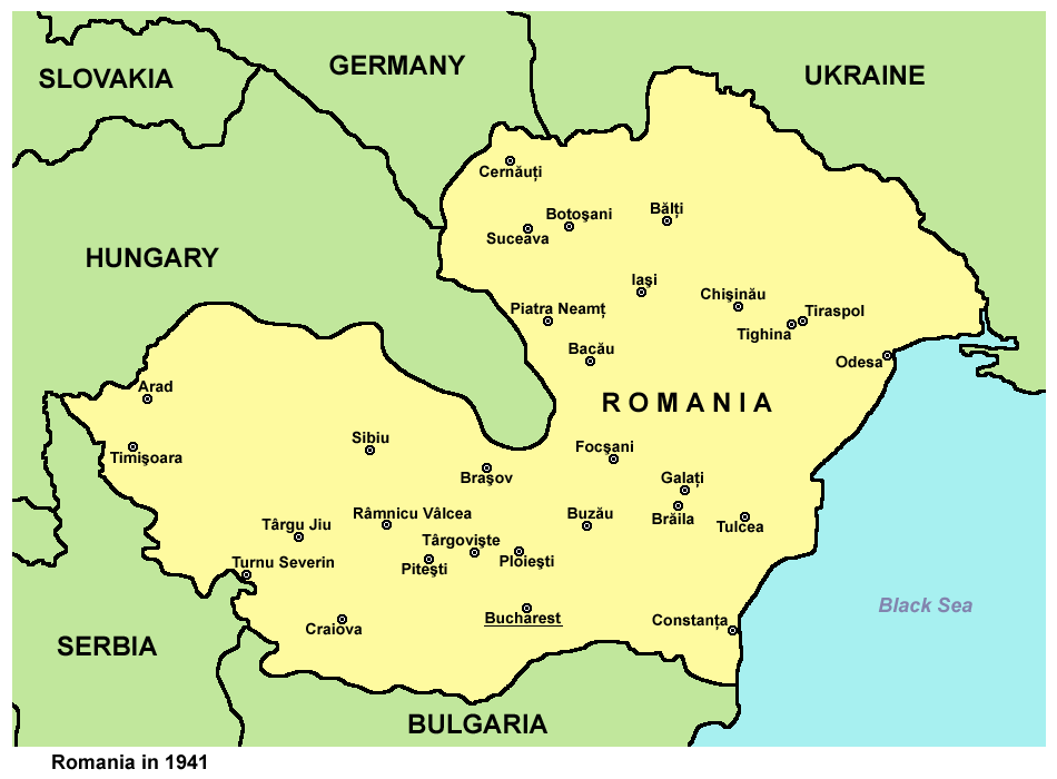
| Frágreiðing | Historic map of Romania in 1941. |
| Dagur | 28 desember 2006 (original upload date) |
| Kelda | Egið verk |
| Høvundur | PANONIAN |
Source and license

|
This map has been uploaded by Electionworld from en.wikipedia.org to enable the |
self made map by user:PANONIAN
Lisensur
| I, the copyright holder of this work, release this work into the public domain. This applies worldwide. In some countries this may not be legally possible; if so: I grant anyone the right to use this work for any purpose, without any conditions, unless such conditions are required by law. |
References
- http://upload.moldova.org/politicom/Transnistria/transnistria_holocaust.gif
- http://kehilalinks.jewishgen.org/sokiryany/1942Romania.gif
- http://academic.evergreen.edu/g/grossmaz/20thCentRomania.jpg
- http://www.ushmm.org/lcmedia/map/lc/image/rom69090.gif
- http://www.ushmm.org/lcmedia/map/lc/image/rom19020.gif
- http://www.ushmm.org/lcmedia/map/lc/image/rom73160.gif
- http://www.freewebs.com/networksromania/_45403710_romania_1942_2009_466.gif
- http://4.bp.blogspot.com/-q2BmrHGgWQ4/Tnr7eEPaGsI/AAAAAAAAAIw/tnEOeauMgMU/s1600/Romania+1941-1944.jpg
- http://www.zum.de/whkmla/histatlas/balkans/rum1941s.gif
Søgan hjá fíluni
Trýst á dato/tíð fyri at síggja fíluna, sum hon sá út tá.
| Dagur/Tíð | Lítil mynd | Dimensjónir | Brúkari | Viðmerking | |
|---|---|---|---|---|---|
| streymur | 29. sep 2012 kl. 13:30 | | 950 × 700 (60 KB) | PANONIAN | improved version |
| 28. des 2006 kl. 18:51 |  | 359 × 253 (13 KB) | Electionworld | {{ew|en|PANONIAN}} historic map of Romania (self made) {{PD-self}} Category:Maps of the history of Romania Category:Maps of World War II in Europe |
Myndarslóðir
Hesar síður slóða til hesa mynd:
Alheims fílunýtsla
Aðrar wkiir brúka hesa fílu:
- Nýtsla á af.wikipedia.org
- Nýtsla á ba.wikipedia.org
- Nýtsla á be-tarask.wikipedia.org
- Nýtsla á be.wikipedia.org
- Nýtsla á bg.wikipedia.org
- Nýtsla á bs.wikipedia.org
- Nýtsla á ca.wikipedia.org
- Nýtsla á cs.wikipedia.org
- Nýtsla á cv.wikipedia.org
- Nýtsla á de.wikipedia.org
- Nýtsla á el.wikipedia.org
- Nýtsla á en.wikipedia.org
- Nýtsla á eo.wikipedia.org
- Nýtsla á eu.wikipedia.org
- Nýtsla á fi.wikipedia.org
- Nýtsla á gl.wikipedia.org
- Nýtsla á gu.wikipedia.org
- Nýtsla á he.wikipedia.org
- Nýtsla á hi.wikipedia.org
- Nýtsla á hr.wikipedia.org
- Nýtsla á hu.wikipedia.org
- Nýtsla á hy.wikipedia.org
- Nýtsla á hyw.wikipedia.org
- Nýtsla á id.wikipedia.org
- Nýtsla á incubator.wikimedia.org
- Nýtsla á is.wikipedia.org
- Nýtsla á it.wikipedia.org
- Nýtsla á ja.wikipedia.org
- Nýtsla á jv.wikipedia.org
- Nýtsla á ko.wikipedia.org
- Nýtsla á lt.wikipedia.org
- Nýtsla á lv.wikipedia.org
- Nýtsla á mk.wikipedia.org
Vís meiri globala nýtslu av hesi fílu.