Mynd:Republic of Venice 1796.png

Stødd av hesi forskoðan: 610 × 600 pixels. Aðrar upploysnir: 244 × 240 pixels | 488 × 480 pixels | 781 × 768 pixels | 1.026 × 1.009 pixels.
Upprunafíla (1.026 × 1.009 pixel, stødd fílu: 115 KB, MIME-slag: image/png)
Samandráttur
| Frágreiðing |
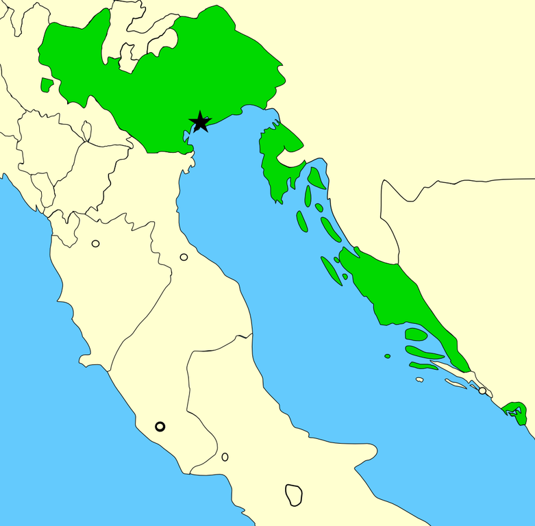
A map showing the territories of the Republic of Venice in the year 1796, before the Napoleonic invasions of that year. Please note that the Venetian-held Ionian Islands are not shown on this map; for a map of these possessions, see Image:Europe 1740.jpg. Created by MapMaster using Image:Italy 1796.png as base. |
| Dagur | 22 november 2006 (original upload date) |
| Kelda | No machine-readable source provided. Own work assumed (based on copyright claims). |
| Høvundur | No machine-readable author provided. MapMaster assumed (based on copyright claims). |
Lisensur
I, the copyright holder of this work, hereby publish it under the following license:

|
Loyvi verður givi at avrita, bera út og/ella broyta hetta skjal undir treytunum hjá GNU Free Documentation License, versión 1.2 ella einhvør seinni versjón ið er útgivin av Free Software Foundation; uttan nakað óbroytiligt brot, uttan forsíðutekst og uttan baksíðutekst. Eitt avrit av loyvinum er tikið við í brotinum ið nevnist GNU Free Documentation License. |
| Henda fíla er gjørd atkomulig undir Creative Commons Navngev-Deil á sama hátt 3.0 Unported loyvinum. | ||
| ||
| This licensing tag was added to this file as part of the GFDL licensing update. |
Søgan hjá fíluni
Trýst á dato/tíð fyri at síggja fíluna, sum hon sá út tá.
| Dagur/Tíð | Lítil mynd | Dimensjónir | Brúkari | Viðmerking | |
|---|---|---|---|---|---|
| streymur | 30. jun 2014 kl. 00:18 | | 1.026 × 1.009 (115 KB) | Ras67 | cropped |
| 24. feb 2008 kl. 15:20 |  | 1.040 × 1.023 (141 KB) | MapMaster | Added small territory | |
| 24. nov 2006 kl. 03:56 |  | 765 × 785 (88 KB) | MapMaster | Now including the Bocche di Cattaro (Bay of Kotor), as suggested by 213 | |
| 22. nov 2006 kl. 05:43 |  | 736 × 763 (90 KB) | MapMaster | A map showing the territories of the Republic of Venice in the year 1796, before the Napoleonic invasions of that year. |
Myndarslóðir
Hesar síður slóða til hesa mynd:
Alheims fílunýtsla
Aðrar wkiir brúka hesa fílu:
- Nýtsla á an.wikipedia.org
- Nýtsla á ar.wikipedia.org
- Nýtsla á az.wikipedia.org
- Nýtsla á be-tarask.wikipedia.org
- Nýtsla á be.wikipedia.org
- Nýtsla á bg.wikipedia.org
- Nýtsla á br.wikipedia.org
- Nýtsla á ca.wikipedia.org
- Nýtsla á da.wikipedia.org
- Nýtsla á de.wikipedia.org
- Nýtsla á en.wikipedia.org
- Nýtsla á eo.wikipedia.org
- Nýtsla á et.wikipedia.org
- Nýtsla á eu.wikipedia.org
- Nýtsla á fr.wikipedia.org
- Nýtsla á fy.wikipedia.org
- Nýtsla á gl.wikipedia.org
- Nýtsla á hr.wikipedia.org
- Nýtsla á hu.wikipedia.org
- Nýtsla á id.wikipedia.org
- Nýtsla á incubator.wikimedia.org
- Nýtsla á it.wikipedia.org
- Nýtsla á ja.wikipedia.org
- Nýtsla á lmo.wikipedia.org
- Nýtsla á lt.wikipedia.org
- Nýtsla á lv.wikipedia.org
- Nýtsla á mk.wikipedia.org
- Nýtsla á nds.wikipedia.org
- Nýtsla á nl.wikipedia.org
Vís meiri globala nýtslu av hesi fílu.