Mynd:Palau location map.svg

Upprunafíla (SVG fíle, nominelt 520 × 709 pixel, fíle stødd: 30 KB)
Samandráttur
| Frágreiðing |
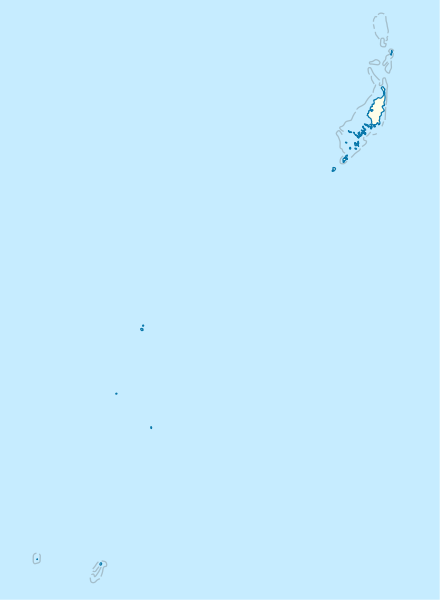
Deutsch: Positionskarte von Palau
Quadratische Plattkarte. Geographische Begrenzung der Karte:
English: Location map of Palau
Equirectangular projection. Geographic limits of the map:
|
|
| Dagur | ||
| Kelda |
Egið verk, using
|
|
| Høvundur | NordNordWest | |
| Loyvi (Endurnýtsla av hesi fílu) |
This file is licensed under the Creative Commons Attribution-Share Alike 3.0 Germany license.
 This file is licensed under the Creative Commons Attribution-Share Alike 3.0 Germany license.
|
|
| Other versions |
|


_location_map.svg)

|
This map has been made or improved in the German Kartenwerkstatt (Map Lab). You can propose maps to improve as well.
|
Søgan hjá fíluni
Trýst á dato/tíð fyri at síggja fíluna, sum hon sá út tá.
| Dagur/Tíð | Lítil mynd | Dimensjónir | Brúkari | Viðmerking | |
|---|---|---|---|---|---|
| streymur | 14. nov 2009 kl. 16:02 | | 520 × 709 (30 KB) | NordNordWest | == {{int:filedesc}} == {{Information |Description= {{de|Positionskarte von Palau}} Quadratische Plattkarte. Geographische Begrenzung der Karte: * N: 8.6° N * S: 2.6° N * W: 130.8° O * O: 135.2° O {{en|Location map of Palau} |
Myndarslóðir
Ongar síður slóða til hesa myndina.
Alheims fílunýtsla
Aðrar wkiir brúka hesa fílu:
- Nýtsla á af.wikipedia.org
- Nýtsla á an.wikipedia.org
- Nýtsla á ar.wikipedia.org
- Nýtsla á ast.wikipedia.org
- Nýtsla á az.wikipedia.org
- Nýtsla á bcl.wikipedia.org
- Nýtsla á be-tarask.wikipedia.org
- Nýtsla á be.wikipedia.org
- Nýtsla á bg.wikipedia.org
- Nýtsla á bn.wikipedia.org
- Nýtsla á bs.wikipedia.org
- Nýtsla á ceb.wikipedia.org
Vís meiri globala nýtslu av hesi fílu.