Mynd:Okterritory.png

Stødd av hesi forskoðan: 800 × 477 pixels. Aðrar upploysnir: 320 × 191 pixels | 640 × 382 pixels | 1.024 × 611 pixels | 1.280 × 763 pixels | 2.515 × 1.500 pixels.
Upprunafíla (2.515 × 1.500 pixel, stødd fílu: 534 KB, MIME-slag: image/png)

|
This locator map image could be re-created using vector graphics as an SVG file. This has several advantages; see Commons:Media for cleanup for more information. If an SVG form of this image is available, please upload it and afterwards replace this template with
{{vector version available|new image name}}.
It is recommended to name the SVG file “Okterritory.svg”—then the template Vector version available (or Vva) does not need the new image name parameter. |
Samandráttur
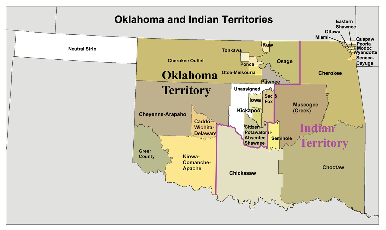
English: A map of the Oklahoma Territory and the reduced Indian Territory circa 1890's.
- In present day Oklahoma.
- Credits
- I made this using Census Bureau data and this 1892 map as a reference.
Lisensur
I, the copyright holder of this work, hereby publish it under the following license:
Henda fíla er gjørd atkomulig undir Creative Commons Navngev-Deil á sama hátt 3.0 Unported loyvinum.
- Tú ert vælkomin til:
- at deila – at avrita, breiða út og senda verkið
- at remiksa – at tillaga ella broyta verkið
- Undir hesum treytum:
- ognan – Tú mást ognarskrivað verkið á ein slíkan hátt sum er útgreinaður av høvundanum ella lisenseigaranum (men ikki á nakran hátt ið kundi bent á at hesin hevur góðkent teg ella tína nýtslu av verkinum).
- deil undir somu treytum – Um tú broytir, evnar til ella byggir víðari á hetta verk, so kanst tú bert útgeva verkið undir somu ella líkandi lisensi sum hesin.
Søgan hjá fíluni
Trýst á dato/tíð fyri at síggja fíluna, sum hon sá út tá.
| Dagur/Tíð | Lítil mynd | Dimensjónir | Brúkari | Viðmerking | |
|---|---|---|---|---|---|
| streymur | 20. jan 2010 kl. 16:34 | | 2.515 × 1.500 (534 KB) | Kmusser | spelling correction |
| 20. jan 2010 kl. 15:10 |  | 2.551 × 1.500 (557 KB) | Kmusser | increased resolution | |
| 31. jul 2006 kl. 18:02 |  | 600 × 358 (33 KB) | Kmusser | == Summary == This is a map of Oklahoma and Indian Territory circa 1890's that I made using and Census Bureau data and [http://hdl.loc.gov/loc.gmd/g4021e.ct000224 this |
Myndarslóðir
Hesar síður slóða til hesa mynd:
Alheims fílunýtsla
Aðrar wkiir brúka hesa fílu:
- Nýtsla á af.wikipedia.org
- Nýtsla á ar.wikipedia.org
- Nýtsla á arz.wikipedia.org
- Nýtsla á bcl.wikipedia.org
- Nýtsla á bn.wikipedia.org
- Nýtsla á ca.wikipedia.org
- Osages
- Chickasaw (grup humà)
- Choctaws
- Wichita (poble)
- Tonkawes
- Caddos
- Comtat de Cimarron
- Comtat de Beaver (Oklahoma)
- Oklahoma Panhandle
- Cinc tribus civilitzades
- Apatxe kiowa
- Territori Indi
- Nació Chickasaw
- Plantilla:Territori Indi
- Nació Choctaw d'Oklahoma
- Districte Apukshunnubbee
- Districte Moshulatubbee
- Districte Pushmataha
- Nació Muscogee
- Estat de Sequoyah
- Nació Seminola d'Oklahoma
- Indian Intercourse Act
- Llei Orgànica d'Oklahoma
- Nýtsla á chr.wikipedia.org
- Nýtsla á chy.wikipedia.org
- Nýtsla á cy.wikipedia.org
- Nýtsla á de.wikipedia.org
Vís meiri globala nýtslu av hesi fílu.