Mynd:Nye fylker - regjeringen.no.svg

Size of this PNG preview of this SVG file: 448 × 599 pixels. Aðrar upploysnir: 179 × 240 pixels | 359 × 480 pixels | 574 × 768 pixels | 765 × 1.024 pixels | 1.531 × 2.048 pixels | 515 × 689 pixels.
Upprunafíla (SVG fíle, nominelt 515 × 689 pixel, fíle stødd: 85 KB)
Samandráttur
| Frágreiðing |
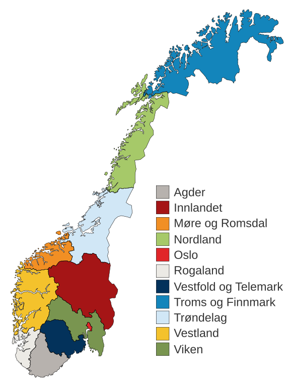
English: Municipal and regional reform: "On 8 June 2017, the Storting decided the following merger of counties". Illustration included.
Norsk bokmål: Kommune- og regionreform: "Stortinget vedtok 8. juni 2017 følgende sammenslåinger av fylker". Medfølgende kart-illustrasjon. |
|||
| Dagur | ||||
| Kelda |
This file was derived from: Fylkeskart-regionreform.jpg |
|||
| Høvundur | Furfur | |||
| Loyvi (Endurnýtsla av hesi fílu) |
|
|||
| Other versions |
|
|||
| SVG genesis | This map was created with Adobe Illustrator. |


Søgan hjá fíluni
Trýst á dato/tíð fyri at síggja fíluna, sum hon sá út tá.
| Dagur/Tíð | Lítil mynd | Dimensjónir | Brúkari | Viðmerking | |
|---|---|---|---|---|---|
| streymur | 3. jan 2020 kl. 01:54 | | 515 × 689 (85 KB) | Furfur | Korr. |
| 3. jan 2020 kl. 01:42 |  | 515 × 689 (85 KB) | Furfur | == {{int:filedesc}} == {{Information |Description={{User:Medium69/Traduction}} {{no|1=Kommune- og regionreform: "Stortinget vedtok 8. juni 2017 følgende sammenslåinger av fylker". Medfølgende kart-illustrasjon. }} |Source={{Derived from|Fylkeskart-regionreform.jpg}} *[https://www.regjeringen.no/no/tema/kommuner-og-regioner/regionreform/regionreform/nye-fylker/id2548426/ Nye fylker] |Date=2020-01-03 |Author={{U|Furfur}} |Permission={{self|GFDL|cc-by-sa-4.0}} |Other versions={{bva|Fylkeskart-re... |
Myndarslóðir
Ongar síður slóða til hesa myndina.
Alheims fílunýtsla
Aðrar wkiir brúka hesa fílu:
- Nýtsla á bs.wikipedia.org
- Nýtsla á ca.wikipedia.org
- Nýtsla á da.wikipedia.org
- Nýtsla á el.wikipedia.org
- Nýtsla á en.wikipedia.org
- Nýtsla á es.wikipedia.org
- Nýtsla á fa.wikipedia.org
- Nýtsla á fi.wikipedia.org
- Nýtsla á he.wikipedia.org
- Nýtsla á hu.wikipedia.org
- Nýtsla á is.wikipedia.org
- Nýtsla á it.wikipedia.org
- Nýtsla á jv.wikipedia.org
- Nýtsla á ko.wikipedia.org
- Nýtsla á nl.wikipedia.org
- Nýtsla á nn.wikipedia.org
Vís meiri globala nýtslu av hesi fílu.