Mynd:National-atlas-vermont.png
Ongin hægri upploysn varð funnin.
National-atlas-vermont.png (763 × 586 pixel, stødd fílu: 82 KB, MIME-slag: image/png)
Transwiki approved by: w:en:User:Dmcdevit
This image was copied from wikipedia:en. The original description was:
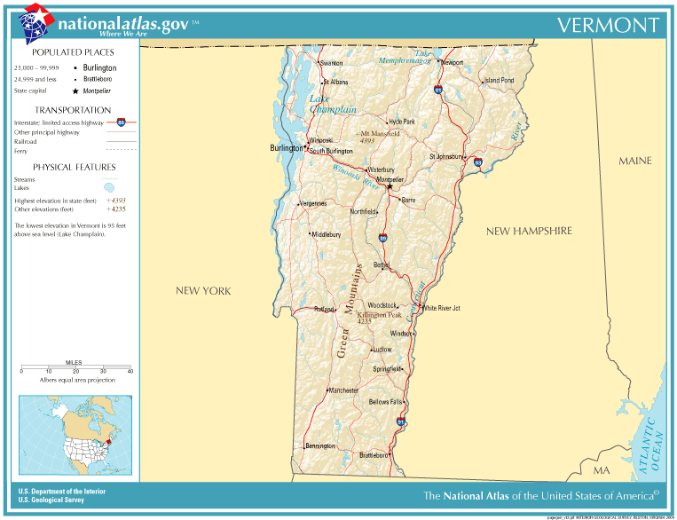
This map was obtained from an edition of the National Atlas of the United States. Like almost all works of the U.S. federal government, works from the National Atlas are in the public domain in the United States.
Online access: NationalAtlas.gov | 1970 print edition: Library of Congress, Perry-Castañeda Library
|
Original upload log
| date/time | username | resolution | size | edit summary |
|---|---|---|---|---|
| 11:34, 13 December 2004 | w:en:User:Berkut | 763×586 | 82 KB | reduced file size |
| 20:26, 4 November 2004 | w:en:User:Jengod | 763×586 | 223 KB | {{PD-USGov}} <a href="/wiki/Category:Vermont_maps" title="Category:Vermont maps">Category:Vermont maps</a> |
Image description page history
| link | date/time | username | edit summary |
|---|---|---|---|
| http://en.wikipedia.org/w/index.php?title=Image:National-atlas-vermont.png&redirect=no&oldid=69888965 | 07:09, 10 September 2007 | w:en:User:Dmcdevit | |
| http://en.wikipedia.org/w/index.php?title=Image:National-atlas-vermont.png&redirect=no&oldid=69888965 | 21:18, 15 August 2006 | w:en:User:Neutrality | |
| http://en.wikipedia.org/w/index.php?title=Image:National-atlas-vermont.png&redirect=no&oldid=16895586 | 22:21, 30 November 2004 | w:en:User:Jengod | |
| http://en.wikipedia.org/w/index.php?title=Image:National-atlas-vermont.png&redirect=no&oldid=7996400 | 20:26, 4 November 2004 | w:en:User:Jengod | ({{PD-USGov}} <a href="/wiki/Category:Vermont_maps" title="Category:Vermont maps">Category:Vermont maps</a>) |
Søgan hjá fíluni
Trýst á dato/tíð fyri at síggja fíluna, sum hon sá út tá.
| Dagur/Tíð | Lítil mynd | Dimensjónir | Brúkari | Viðmerking | |
|---|---|---|---|---|---|
| streymur | 10. sep 2007 kl. 16:02 | | 763 × 586 (82 KB) | BetacommandBot | Transwiki approved by: w:en:User:Dmcdevit This image was copied from wikipedia:en. The original description was: {{PD-USGov-Atlas}} w:en:Category:Vermont maps === File history === {| class=wikitable ! date/time || username || resolution || siz |
Myndarslóðir
Hesar síður slóða til hesa mynd:
Alheims fílunýtsla
Aðrar wkiir brúka hesa fílu:
- Nýtsla á bg.wikipedia.org
- Nýtsla á bn.wikipedia.org
- Nýtsla á en.wikipedia.org
- Nýtsla á fr.wikipedia.org
- Nýtsla á gu.wikipedia.org
- Nýtsla á id.wikipedia.org
- Nýtsla á io.wikipedia.org
- Nýtsla á ja.wikipedia.org
- Nýtsla á lt.wikipedia.org
- Nýtsla á nl.wikipedia.org
- Nýtsla á pam.wikipedia.org