Mynd:NO 2100 Longyearbyen.svg

Size of this PNG preview of this SVG file: 380 × 420 pixels. Aðrar upploysnir: 217 × 240 pixels | 434 × 480 pixels | 695 × 768 pixels | 926 × 1.024 pixels | 1.853 × 2.048 pixels.
Upprunafíla (SVG fíle, nominelt 380 × 420 pixel, fíle stødd: 24 KB)
Samandráttur
| Frágreiðing |
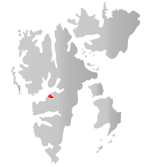
Norsk nynorsk: Kart som viser plasseringa tili . English: Map showing the position of Longyearbyen within Svalbard. |
||
| Dagur | |||
| Kelda | Own work based on: NO 2100 Longyearbyen.png | ||
| Høvundur | Fleinn | ||
| Loyvi (Endurnýtsla av hesi fílu) |
|
||
| SVG genesis |
Lisensur
| I, the copyright holder of this work, release this work into the public domain. This applies worldwide. In some countries this may not be legally possible; if so: I grant anyone the right to use this work for any purpose, without any conditions, unless such conditions are required by law. |
Søgan hjá fíluni
Trýst á dato/tíð fyri at síggja fíluna, sum hon sá út tá.
| Dagur/Tíð | Lítil mynd | Dimensjónir | Brúkari | Viðmerking | |
|---|---|---|---|---|---|
| streymur | 14. jul 2010 kl. 18:29 | | 380 × 420 (24 KB) | Fleinn | {{Information |Description={{nn|1=Kart som viser plasseringa til Longyearbyen i Svalbard.}} |Source=Based upon File:NO 2100 Longyearbyen.png |Author=Own work {{Created with Inkscape}} |Date=2010-07-14 | |
Myndarslóðir
Hesar síður slóða til hesa mynd:
Alheims fílunýtsla
Aðrar wkiir brúka hesa fílu:
- Nýtsla á ar.wikipedia.org
- Nýtsla á arz.wikipedia.org
- Nýtsla á ast.wikipedia.org
- Nýtsla á bs.wikipedia.org
- Nýtsla á ca.wikipedia.org
- Nýtsla á da.wikipedia.org
- Nýtsla á diq.wikipedia.org
- Nýtsla á el.wikipedia.org
- Nýtsla á en.wikipedia.org
- Nýtsla á eo.wikipedia.org
- Nýtsla á es.wikipedia.org
- Nýtsla á eu.wikipedia.org
- Nýtsla á fa.wikipedia.org
- Nýtsla á fr.wikipedia.org
- Nýtsla á gl.wikipedia.org
- Nýtsla á gv.wikipedia.org
- Nýtsla á ie.wikipedia.org
- Nýtsla á ja.wikipedia.org
- Nýtsla á ko.wikipedia.org
- Nýtsla á mzn.wikipedia.org
- Nýtsla á nn.wikipedia.org
- Nýtsla á pms.wikipedia.org
- Nýtsla á pnb.wikipedia.org
- Nýtsla á ps.wikipedia.org
- Nýtsla á pt.wikipedia.org
- Nýtsla á ro.wikipedia.org
- Nýtsla á se.wikipedia.org
- Nýtsla á sl.wikipedia.org
- Nýtsla á sr.wikipedia.org
- Nýtsla á ta.wikipedia.org
- Nýtsla á th.wikipedia.org
- Nýtsla á ur.wikipedia.org
- Nýtsla á vi.wikipedia.org
- Nýtsla á www.wikidata.org
- Nýtsla á zh-min-nan.wikipedia.org
- Nýtsla á zh.wikipedia.org