Mynd:Map of the tunnels of the Faroe Islands.png

Stødd av hesi forskoðan: 568 × 600 pixels. Aðrar upploysnir: 227 × 240 pixels | 455 × 480 pixels | 728 × 768 pixels | 970 × 1.024 pixels | 1.940 × 2.048 pixels | 3.027 × 3.195 pixels.
Upprunafíla (3.027 × 3.195 pixel, stødd fílu: 3,21 MB, MIME-slag: image/png)

|
This map image could be re-created using vector graphics as an SVG file. This has several advantages; see Commons:Media for cleanup for more information. If an SVG form of this image is available, please upload it and afterwards replace this template with
{{vector version available|new image name}}.
It is recommended to name the SVG file “Map of the tunnels of the Faroe Islands.svg”—then the template Vector version available (or Vva) does not need the new image name parameter. |
| Frágreiðing |
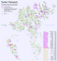
Català: Mapa dels túnels de les Illes Fèroe
Deutsch: Karte der Tunnel auf den Färöern
English: Map of the tunnels of the Faroe Islands |
| Dagur | see file history |
| Kelda | Egið verk, using Openstreetmap data for the background |
| Høvundur | Maximilian Dörrbecker (Chumwa) |
| Loyvi (Endurnýtsla av hesi fílu) |
All OpenStreetMap data and maps are Creative Commons "CC-BY-SA 2.0" licensed This file is licensed under the Creative Commons Attribution-Share Alike 2.0 Generic license.
|
Søgan hjá fíluni
Trýst á dato/tíð fyri at síggja fíluna, sum hon sá út tá.
| Dagur/Tíð | Lítil mynd | Dimensjónir | Brúkari | Viðmerking | |
|---|---|---|---|---|---|
| streymur | 19. des 2020 kl. 18:19 | | 3.027 × 3.195 (3,21 MB) | Karl432 | Eysturoyatunnilin opened on 2020-12-19 |
| 23. des 2016 kl. 07:51 |  | 3.027 × 3.195 (3,21 MB) | Chumwa | ||
| 21. des 2016 kl. 16:31 |  | 3.027 × 3.195 (3,02 MB) | Chumwa | ||
| 20. des 2016 kl. 23:09 |  | 3.011 × 3.195 (946 KB) | Chumwa | ||
| 20. des 2016 kl. 22:34 |  | 3.011 × 3.195 (942 KB) | Chumwa | ||
| 19. des 2016 kl. 21:15 |  | 3.011 × 3.195 (929 KB) | Chumwa | ||
| 19. des 2016 kl. 06:36 |  | 3.011 × 3.195 (904 KB) | Chumwa | ||
| 18. des 2016 kl. 23:05 |  | 3.011 × 3.195 (886 KB) | Chumwa | ||
| 18. des 2016 kl. 18:53 |  | 3.011 × 3.195 (902 KB) | Chumwa | {{Information |Description= {{de|Karte der Tunnel auf den Färöern}} {{en|Map of the tunnels of the Faroe Islands}} |Author=Maximilian Dörrbecker (Chumwa) |Source={{own}}, using Openstreetmap data for the back... |
Myndarslóðir
Hesar síður slóða til hesa mynd:
Alheims fílunýtsla
Aðrar wkiir brúka hesa fílu:
- Nýtsla á ca.wikipedia.org
- Nýtsla á cs.wikipedia.org
- Nýtsla á da.wikipedia.org
- Nýtsla á de.wikipedia.org
- Nýtsla á en.wikipedia.org
- Nýtsla á en.wikivoyage.org
- Nýtsla á fr.wikipedia.org
- Nýtsla á hu.wikipedia.org
- Nýtsla á is.wikipedia.org
- Nýtsla á it.wikipedia.org
- Nýtsla á nl.wikipedia.org
- Nýtsla á no.wikipedia.org
- Nýtsla á sv.wikipedia.org