Mynd:Map of Michigan NA.png
Stødd av hesi forskoðan: 776 × 600 pixels. Aðrar upploysnir: 311 × 240 pixels | 621 × 480 pixels | 994 × 768 pixels | 1.280 × 989 pixels | 2.122 × 1.640 pixels.
Upprunafíla (2.122 × 1.640 pixel, stødd fílu: 1,21 MB, MIME-slag: image/png)
Samandráttur
| Frágreiðing |
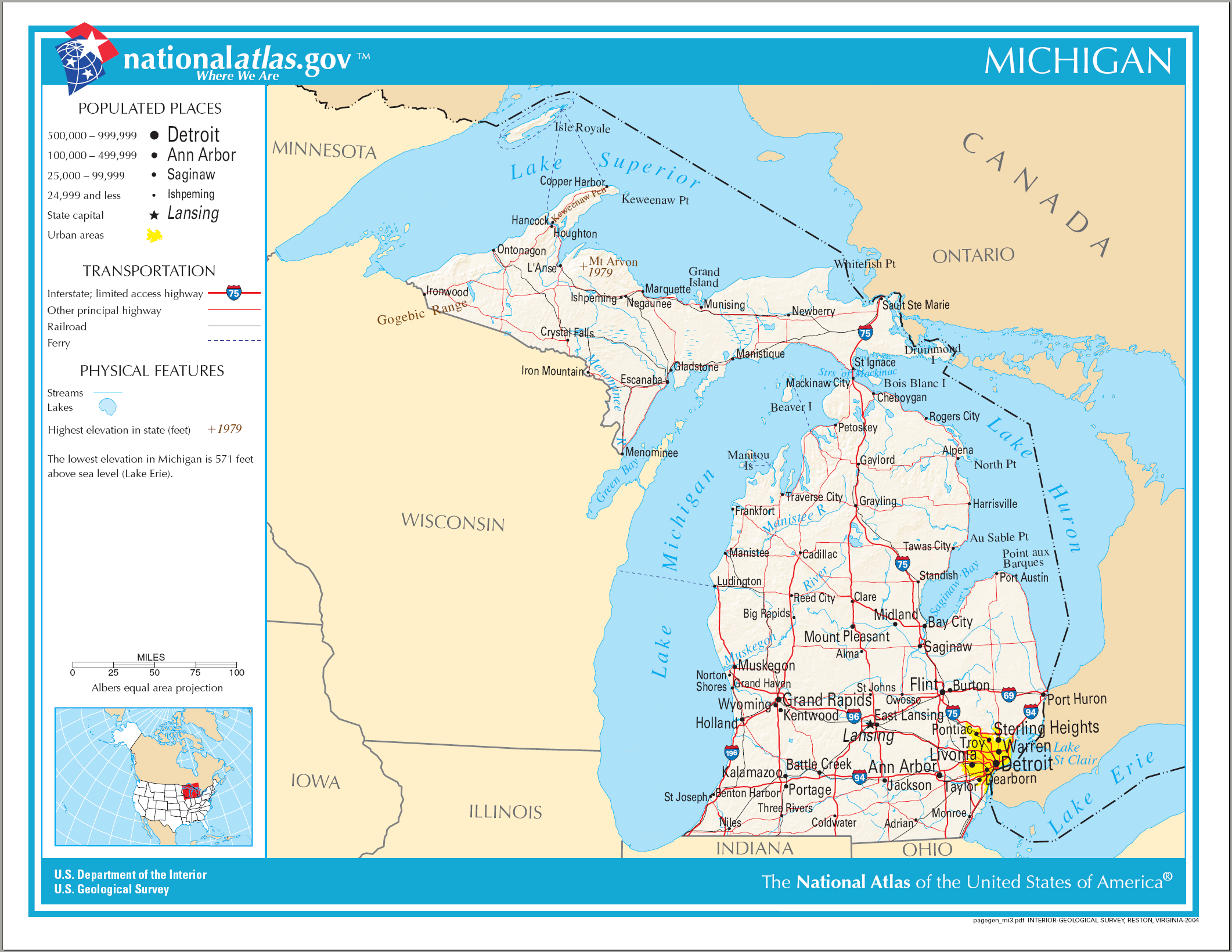
English: Map of Michigan |
| Dagur | |
| Kelda | National Atlas |
| Høvundur |
Lisensur
This map was obtained from an edition of the National Atlas of the United States. Like almost all works of the U.S. federal government, works from the National Atlas are in the public domain in the United States.
Online access: NationalAtlas.gov | 1970 print edition: Library of Congress, Perry-Castañeda Library
|
Søgan hjá fíluni
Trýst á dato/tíð fyri at síggja fíluna, sum hon sá út tá.
| Dagur/Tíð | Lítil mynd | Dimensjónir | Brúkari | Viðmerking | |
|---|---|---|---|---|---|
| streymur | 14. aug 2006 kl. 21:09 | | 2.122 × 1.640 (1,21 MB) | Huebi~commonswiki | {{Information| |Description=Map of Michigan |Source=[http://www.nationalatlas.gov National Atlas] }} Category:Maps of the United States Category:Maps of Michigan {{PD-USGov-Atlas}} |
Myndarslóðir
Hesar síður slóða til hesa mynd:
Alheims fílunýtsla
Aðrar wkiir brúka hesa fílu:
- Nýtsla á ca.wikipedia.org
- Nýtsla á de.wikipedia.org
- Nýtsla á en.wikipedia.org
- Nýtsla á hr.wiktionary.org
- Nýtsla á hsb.wikipedia.org
- Nýtsla á ilo.wikipedia.org
- Nýtsla á incubator.wikimedia.org
- Nýtsla á it.wikipedia.org
- Nýtsla á kn.wikipedia.org
- Nýtsla á lij.wikipedia.org
- Nýtsla á ru.wikivoyage.org
- Nýtsla á simple.wikipedia.org
- Nýtsla á si.wikipedia.org
- Nýtsla á sl.wikipedia.org
- Nýtsla á sw.wikipedia.org
- Nýtsla á zea.wikipedia.org