Mynd:Map of Australia.png
Ongin hægri upploysn varð funnin.
Map_of_Australia.png (328 × 352 pixel, stødd fílu: 20 KB, MIME-slag: image/png)

|
This locator map image could be re-created using vector graphics as an SVG file. This has several advantages; see Commons:Media for cleanup for more information. If an SVG form of this image is available, please upload it and afterwards replace this template with
{{vector version available|new image name}}.
It is recommended to name the SVG file “Map of Australia.svg”—then the template Vector version available (or Vva) does not need the new image name parameter. |
Samandráttur
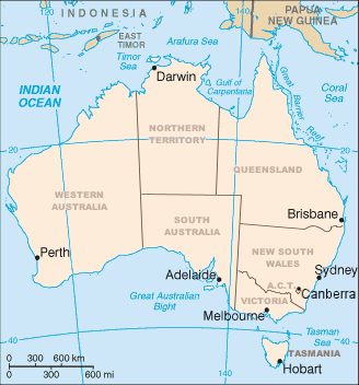
Map of Australia showing the states and capital cities. Modified from a CIA World Factbook image by Mark Ryan. Australian maps are not considerable for true constents
Lisensur

|
Loyvi verður givi at avrita, bera út og/ella broyta hetta skjal undir treytunum hjá GNU Free Documentation License, versión 1.2 ella einhvør seinni versjón ið er útgivin av Free Software Foundation; uttan nakað óbroytiligt brot, uttan forsíðutekst og uttan baksíðutekst. Eitt avrit av loyvinum er tikið við í brotinum ið nevnist GNU Free Documentation License. Subject to disclaimers. |
Søgan hjá fíluni
Trýst á dato/tíð fyri at síggja fíluna, sum hon sá út tá.
| Dagur/Tíð | Lítil mynd | Dimensjónir | Brúkari | Viðmerking | |
|---|---|---|---|---|---|
| streymur | 10. apr 2006 kl. 02:12 | | 328 × 352 (20 KB) | Mark | Map of Australia showing the states and capital cities. Modified from a CIA World Factbook image by Mark Ryan. |
Myndarslóðir
Hesar síður slóða til hesa mynd:
Alheims fílunýtsla
Aðrar wkiir brúka hesa fílu:
- Nýtsla á an.wikipedia.org
- Nýtsla á ar.wikipedia.org
- Nýtsla á be-tarask.wikipedia.org
- Nýtsla á bg.wikipedia.org
- Nýtsla á bh.wikipedia.org
- Nýtsla á ca.wikipedia.org
- Nýtsla á de.wikipedia.org
- Nýtsla á diq.wikipedia.org
- Nýtsla á en.wikipedia.org
- 1900
- Index of Australia-related articles
- User:Snovv
- United Nations Association of Australia
- Template:Australia states imagemap
- Geography of Australia
- Wikipedia:Graphics Lab/Map workshop/Archive/Dec 2011
- List of marine animals of Australia (temperate waters)
- Luggenemenener
- User:Maxmead2/sandbox
- Template:Australia states imagemap/sandbox
- Template:Australia states imagemap/testcases
- User:Ambiloo/sandbox
- Nýtsla á en.wikiversity.org
- Nýtsla á es.wikipedia.org
- Nýtsla á fr.wikipedia.org
- Nýtsla á gl.wikipedia.org
- Nýtsla á gom.wikipedia.org
- Nýtsla á hi.wikipedia.org
- Nýtsla á hu.wikipedia.org
- Nýtsla á id.wikipedia.org
Vís meiri globala nýtslu av hesi fílu.