Mynd:Map-kommunur-foroya-2009.png
Stødd av hesi forskoðan: 450 × 600 pixels. Aðrar upploysnir: 180 × 240 pixels | 600 × 800 pixels.
Upprunafíla (600 × 800 pixel, stødd fílu: 57 KB, MIME-slag: image/png)
Samandráttur
| Frágreiðing |
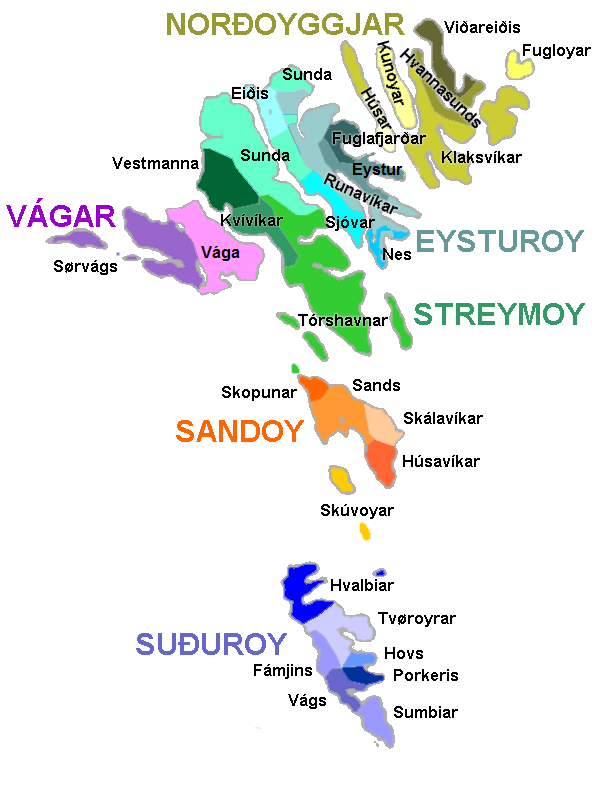
English: Map of the municipalities of the Faroe Islands, as of January 1, 2009.
Norsk bokmål: Kart over kommunene på Færøyene av 1. januar 2009.
Føroyskt: Kort yvir kommununum í Føroyum síðan 1. januar 2009. |
| Dagur | |
| Kelda | Egið verk |
| Høvundur | Erik Fløan |
| Other versions | 2005 edition |
Lisensur
| I, the copyright holder of this work, release this work into the public domain. This applies worldwide. In some countries this may not be legally possible; if so: I grant anyone the right to use this work for any purpose, without any conditions, unless such conditions are required by law. |
Søgan hjá fíluni
Trýst á dato/tíð fyri at síggja fíluna, sum hon sá út tá.
| Dagur/Tíð | Lítil mynd | Dimensjónir | Brúkari | Viðmerking | |
|---|---|---|---|---|---|
| streymur | 6. jan 2009 kl. 16:44 | | 600 × 800 (57 KB) | Efloean | {{Information |Description={{en|1=Map of the municipalities of the Faroe Islands, as of January 1, 2009.}} {{no|1=Kart over kommunene på Færøyene av 1. januar 2009.}} {{fo|1=Kort yvir kommununum í Føroyum síðan 1. januar 2009.}} |Source=Own work |A |
| 6. jan 2009 kl. 16:39 |  | 600 × 800 (57 KB) | Efloean | {{Information |Description={{en|1=Map of the municipalities of the Faroe Islands, as of January 1, 2009.}} {{no|1=Kart over kommunene på Færøyene av 1. januar 2009.}} {{fo|1=Kort yvir kommunur Føroya síðan 1. januar 2009.}} |Source=Own work |Author= |
Myndarslóðir
Ongar síður slóða til hesa myndina.
Alheims fílunýtsla
Aðrar wkiir brúka hesa fílu:
- Nýtsla á da.wikipedia.org
- Nýtsla á de.wikipedia.org
- Nýtsla á en.wikipedia.org
- Nýtsla á en.wiktionary.org
- Nýtsla á eu.wikipedia.org
- Nýtsla á fi.wikipedia.org
- Nýtsla á fr.wikipedia.org
- Nýtsla á hu.wikipedia.org
- Nýtsla á lt.wikipedia.org
- Nýtsla á no.wikipedia.org
- Nýtsla á pl.wikipedia.org
Vís meiri globala nýtslu av hesi fílu.