Mynd:Liechtenstein topographic map-de Version Tschubby.png

Stødd av hesi forskoðan: 458 × 599 pixels. Aðrar upploysnir: 183 × 240 pixels | 367 × 480 pixels | 587 × 768 pixels | 783 × 1.024 pixels | 2.189 × 2.862 pixels.
Upprunafíla (2.189 × 2.862 pixel, stødd fílu: 2,2 MB, MIME-slag: image/png)
Samandráttur
| Frágreiðing |
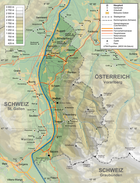
Deutsch: Topographische Karte von Liechtenstein, deutsche Version English: Topographic map in German of Liechtenstein Français : Carte topographique en allemand du Liechtenstein |
| Dagur | |
| Kelda |
English: Own work ; Topographic data from the NASA Shuttle Radar Topography Mission (SRTM3 v.2) (public domain) edited with 3DEM and dlgv32 Pro, and vectorized with Inkscape ; UTM projection ; WGS84 datum ; shaded relief (N-W lightning positions) edited with The Gimp ; Reference used for the additional data : * Rivers, cities, railroads, routes, bathymetry : Demis add-on for World Wind (see the approval e-mail and the Demis forum) ; * Borders and coast : World data bank II + + File:Liechtenstein-admin.png by user:Aotearoa ; Approximate scale of topographic data : 1:1,463,000 ; Note : The shaded relief is a raster image embedded in the SVG file. Français : Création personnelle ; Données topographiques de la NASA Shuttle Radar Topography Mission (SRTM3 v.2) (domaine public) éditées avec 3DEM etdlgv32 Pro, et vectorisées avec Inkscape ; projection UTM ; WGS84 datum ; relief ombré (éclairage du N-O) édité avec The Gimp ; Références utilisées pour les données complémentaires : * Rivières, villes, chemins de fers, routes, bathymétrie : Demis add-on for World Wind (cf. l'e-mail d'approbation de Demis et le Demis forum) ; * Frontières et côtes : World data bank II + File:Liechtenstein-admin.png de user:Aotearoa ; Échelle approximative des données topographiques : 1:1 463 000 ; Note : Le relief ombré est une image bitmap embarquée dans le fichier SVG. Approximate geographic limits of the map (30" close) : * SW corner : 47°02'05"N – 9°40'00"E * SE corner : 47°02'05"N – 9°70'00"E * NE corner : 47°27'55"N – 9°70'00"E * NW corner : 47°27'55"N – 9°40'00"E |
| Høvundur | Bourrichon, translated by NordNordWest, new Design by Tschubby |
| Loyvi (Endurnýtsla av hesi fílu) |
GFDL / Attribution and Share-Alike required |
| Other versions |
|


Lisensur
I, the copyright holder of this work, hereby publish it under the following licenses:

|
Loyvi verður givi at avrita, bera út og/ella broyta hetta skjal undir treytunum hjá GNU Free Documentation License, versión 1.2 ella einhvør seinni versjón ið er útgivin av Free Software Foundation; uttan nakað óbroytiligt brot, uttan forsíðutekst og uttan baksíðutekst. Eitt avrit av loyvinum er tikið við í brotinum ið nevnist GNU Free Documentation License. |
This file is licensed under the Creative Commons Attribution-Share Alike 4.0 International, 3.0 Unported, 2.5 Generic, 2.0 Generic and 1.0 Generic license.
- Tú ert vælkomin til:
- at deila – at avrita, breiða út og senda verkið
- at remiksa – at tillaga ella broyta verkið
- Undir hesum treytum:
- ognan – Tú mást ognarskrivað verkið á ein slíkan hátt sum er útgreinaður av høvundanum ella lisenseigaranum (men ikki á nakran hátt ið kundi bent á at hesin hevur góðkent teg ella tína nýtslu av verkinum).
- deil undir somu treytum – Um tú broytir, evnar til ella byggir víðari á hetta verk, so kanst tú bert útgeva verkið undir somu ella líkandi lisensi sum hesin.
Tú kanst velja tann lisens ið tú ynskir.
Søgan hjá fíluni
Trýst á dato/tíð fyri at síggja fíluna, sum hon sá út tá.
| Dagur/Tíð | Lítil mynd | Dimensjónir | Brúkari | Viðmerking | |
|---|---|---|---|---|---|
| streymur | 3. feb 2016 kl. 14:05 | | 2.189 × 2.862 (2,2 MB) | RokerHRO | optipng -o7 -zm1-9 -i0 → 48.70% decrease |
| 12. feb 2012 kl. 11:37 |  | 2.189 × 2.862 (4,3 MB) | Tschubby | {{Information |Description= |Source= |Date= |Author= |Permission= |other_versions= }} | |
| 12. feb 2012 kl. 11:31 |  | 2.189 × 2.862 (8,6 MB) | Tschubby | {{Information |Description= |Source= |Date= |Author= |Permission= |other_versions= }} | |
| 26. jan 2012 kl. 16:17 |  | 1.305 × 1.683 (2,3 MB) | Tschubby | {{Information |Description= |Source= |Date= |Author= |Permission= |other_versions= }} | |
| 26. jan 2012 kl. 16:13 |  | 794 × 1.024 (1,26 MB) | Tschubby | {{Information |Description= |Source= |Date= |Author= |Permission= |other_versions= }} | |
| 21. jul 2009 kl. 09:05 |  | 1.305 × 1.683 (1,46 MB) | Tschubby | {{Information |Description= |Source= |Date= |Author= |Permission= |other_versions= }} | |
| 21. jul 2009 kl. 08:50 |  | 1.338 × 1.683 (1,48 MB) | Tschubby | == Summary == {{Information |Description={{de|Topographische Karte von Liechtenstein, deutsche Version}}{{en|Topographic map in German of Liechtenstein}}{{fr|Carte topographique en allemand du [[:fr:Liechtenstei |
Myndarslóðir
Hesar síður slóða til hesa mynd:
Alheims fílunýtsla
Aðrar wkiir brúka hesa fílu:
- Nýtsla á af.wikipedia.org
- Nýtsla á als.wikipedia.org
- Nýtsla á de.wikipedia.org
- Nýtsla á es.wikipedia.org
- Nýtsla á frr.wikipedia.org
- Nýtsla á pdc.wikipedia.org
- Nýtsla á pfl.wikipedia.org
- Nýtsla á rm.wikipedia.org