Mynd:Kingdom of Mann and the Isles-en.svg

Size of this PNG preview of this SVG file: 571 × 600 pixels. Aðrar upploysnir: 229 × 240 pixels | 457 × 480 pixels | 731 × 768 pixels | 975 × 1.024 pixels | 1.950 × 2.048 pixels | 1.297 × 1.362 pixels.
Upprunafíla (SVG fíle, nominelt 1.297 × 1.362 pixel, fíle stødd: 209 KB)
Samandráttur
| Frágreiðing |
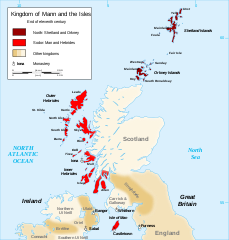
English: Map of the kingdom of Mann and the Isles, nearly the end of eleventh century.
Norðr: Shetland and Orkney
Sodor: Man and Hebrides Français : Carte du royaume de Man et des Îles, vers la fin du onzième siècle.
Norðr : Shetland et Orcades
Sodor : Man et Hebrides |
||
| Dagur | |||
| Kelda |
Own work based on: British Isles.svg, Mormaerdoms.png and Www.wesleyjohnston.com-users-ireland-maps-historical-map1014.gif |
||
| Høvundur | Sémhur | ||
| Other versions |
Derivative works of this file: Kingdom of Mann and the Isles-es.svg
|
||
| Ognan (required by the license) | © Sémhur / Wikimedia Commons / | ||
| SVG | W3C-validity not checked.
|
||
| Atelier graphique |

| Camera location | | View this and other nearby images on: OpenStreetMap |
|---|
Lisensur
I, the copyright holder of this work, hereby publish it under the following licenses:
| Copyleft: This work of art is free; you can redistribute it and/or modify it according to terms of the Free Art License. You will find a specimen of this license on the Copyleft Attitude site as well as on other sites. |
This file is licensed under the Creative Commons Attribution-Share Alike 3.0 Unported, 2.5 Generic, 2.0 Generic and 1.0 Generic license.
- Tú ert vælkomin til:
- at deila – at avrita, breiða út og senda verkið
- at remiksa – at tillaga ella broyta verkið
- Undir hesum treytum:
- ognan – Tú mást ognarskrivað verkið á ein slíkan hátt sum er útgreinaður av høvundanum ella lisenseigaranum (men ikki á nakran hátt ið kundi bent á at hesin hevur góðkent teg ella tína nýtslu av verkinum).
- deil undir somu treytum – Um tú broytir, evnar til ella byggir víðari á hetta verk, so kanst tú bert útgeva verkið undir somu ella líkandi lisensi sum hesin.
Tú kanst velja tann lisens ið tú ynskir.
Søgan hjá fíluni
Trýst á dato/tíð fyri at síggja fíluna, sum hon sá út tá.
| Dagur/Tíð | Lítil mynd | Dimensjónir | Brúkari | Viðmerking | |
|---|---|---|---|---|---|
| streymur | 26. des 2015 kl. 20:06 | | 1.297 × 1.362 (209 KB) | Alphathon | Various minor corrections/tweaks |
| 15. okt 2007 kl. 10:06 |  | 1.297 × 1.362 (208 KB) | Sémhur | {{Information |Description=Map of the kingdom of Mann and the Isles, nearly the end of eleventh century |Source=Own work, from : * Map of British Isles * [[:Image:Mormaerdoms.png|Map of kingdoms of Scotland in the Middle Ages] |
Myndarslóðir
Hesar síður slóða til hesa mynd:
Alheims fílunýtsla
Aðrar wkiir brúka hesa fílu:
- Nýtsla á af.wikipedia.org
- Nýtsla á be.wikipedia.org
- Nýtsla á bn.wikipedia.org
- Nýtsla á br.wikipedia.org
- Nýtsla á ca.wikipedia.org
- Nýtsla á cs.wikipedia.org
- Nýtsla á cy.wikipedia.org
- Nýtsla á da.wikipedia.org
- Nýtsla á de.wikipedia.org
- Nýtsla á el.wikipedia.org
- Nýtsla á en.wikipedia.org
- Hebrides
- Isle of Man
- History of the Isle of Man
- Norn language
- Scotland
- Outer Hebrides
- Kingdom of the Isles
- Slate Islands
- Diocese of Sodor and Man
- User:Jnestorius/Regions with significant island landmass
- Earldom of Orkney
- Thorfinn the Mighty
- List of early Germanic peoples
- Norse–Gaels
- Scotland in the High Middle Ages
- Portal:Middle Ages/Selected article
- Portal:Middle Ages/Selected article/10
- Manx runestones
- Viking expansion
- Kewish
- King of Mann
- List of active separatist movements in Europe
- Scottish island names
- Portal:Scotland/Selected article/2012
- Scandinavian Scotland
- Portal:Scotland/Selected article/Week 2, 2012
- Portal:Scotland/Selected article/2016
- Portal:Scotland/Selected article/Week 2, 2016
- Nýtsla á es.wikipedia.org
- Nýtsla á eu.wikipedia.org
Vís meiri globala nýtslu av hesi fílu.