Mynd:Greater London UK location map 2.svg

Size of this PNG preview of this SVG file: 750 × 600 pixels. Aðrar upploysnir: 300 × 240 pixels | 600 × 480 pixels | 960 × 768 pixels | 1.280 × 1.024 pixels | 2.560 × 2.048 pixels | 1.425 × 1.140 pixels.
Upprunafíla (SVG fíle, nominelt 1.425 × 1.140 pixel, fíle stødd: 2,18 MB)
| Frágreiðing |
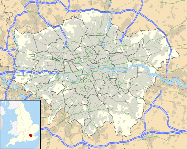
Map of Greater London, UK with the following information shown:
The data includes both primary routes and railway lines. Equirectangular map projection on WGS 84 datum, with N/S stretched 160% Geographic limits:
|
| Dagur | |
| Kelda |
|
| Høvundur | Nilfanion, created using Ordnance Survey data |
| Loyvi (Endurnýtsla av hesi fílu) |
Henda fíla er gjørd atkomulig undir Creative Commons Navngev-Deil á sama hátt 3.0 Unported loyvinum. Ognan: Contains Ordnance Survey data © Crown copyright and database right
|
| Other versions | File:Greater London UK district map (blank).svg - Blank map, File:Greater London UK location map.svg - excluding primary routes and railways |
.svg)
Søgan hjá fíluni
Trýst á dato/tíð fyri at síggja fíluna, sum hon sá út tá.
| Dagur/Tíð | Lítil mynd | Dimensjónir | Brúkari | Viðmerking | |
|---|---|---|---|---|---|
| streymur | 5. okt 2010 kl. 17:43 | | 1.425 × 1.140 (2,18 MB) | Nilfanion | {{Information |Description=Map of Greater London, UK with the following information shown: *Administrative borders *Coastline, lakes and rivers *Roads and railways *Urban areas The data includes both primary routes and railway lines. |
Myndarslóðir
Hesar síður slóða til hesa mynd:
- Premier League 2012-13
- Premier League 2015-16
- Premier League 2016-17
- Premier League 2017-18
- Premier League 2018-19
- Premier League 2019-20
- Premier League 2020-21
- Premier League 2021-22
- Premier League 2022-23
- Premier League 2023-24
- Fyrimynd:Infobox UK place/doc/London
- Fyrimynd:Location map United Kingdom Greater London
Alheims fílunýtsla
Aðrar wkiir brúka hesa fílu:
- Nýtsla á af.wikipedia.org
- Londense Tower
- Westminster-abdy
- Twickenham
- Greenwich (Londen)
- Penge (Londen)
- Paleis van Westminster
- Canary Wharf
- St John's Wood
- Marylebone
- Stratford, Londen
- Queen Elizabeth Olympic Park
- Sjabloon:Liggingkaart Groter Londen
- Leyton
- Charing Cross
- Lughawe Londen-Heathrow
- Strand, Londen
- Muswell Hill
- London City-lughawe
- Dulwich Village
- Hampstead
- Silvertown
- Shoreditch
- Islington
- Clerkenwell
- Holland Park
- Soho
- Chelsea, Londen
- Southwark
- Hackney Central
- Notting Hill
- Paddington
- Crouch End
- Highgate
- Primrose Hill
- Bloomsbury
- Camden Town
- Spitalfields
- Vauxhall
- Holborn
- Kensington
- Battersea
- Belgravia
- Limehouse
- Bishopsgate
- Nýtsla á ar.wikipedia.org
Vís meiri globala nýtslu av hesi fílu.