Mynd:Europe subregion map UN geoscheme.svg

Size of this PNG preview of this SVG file: 680 × 520 pixels. Aðrar upploysnir: 314 × 240 pixels | 628 × 480 pixels | 1.004 × 768 pixels | 1.280 × 979 pixels | 2.560 × 1.958 pixels.
Upprunafíla (SVG fíle, nominelt 680 × 520 pixel, fíle stødd: 228 KB)
Samandráttur
| Frágreiðing |
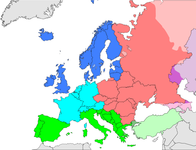
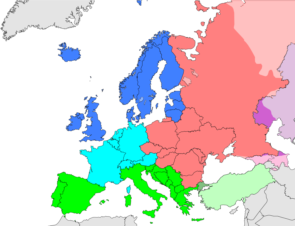
Deutsch: Subregionen Europas (nach UN Geoschema)
Nordeuropa
Westeuropa
Osteuropa
Südeuropa English: Subregions of Europe (UN geoscheme)
Northern Europe
Western Europe
Eastern Europe
Southern Europe
Countries of West Asia with partial territory in Southern Europe: Turkey
Countries of West Asia with partial territory in Eastern Europe: Georgia and Azerbaijan
Countries of Central Asia with partial territory in Eastern Europe: Kazakhstan
Русский: Макрорегионы Европы (классификация ООН)
Северная Европа
Западная Европа
Восточная Европа
Южная Европа
Страны макрорегиона Западная Азия с частичной территорией в Южной Европе: Турция
Страны макрорегиона Западная Азия с частичной территорией в Восточной Европе: Азербайджан и Грузия
Страны макрорегиона Центральная Азия с частичной территорией в Восточной Европе: Казахстан
Українська: Підрегіони Європи (класифікація Організації Об’єднаних Націй)
Північна Європа
Західна Європа
Східна Європа
Південна Європа |
| Dagur | |
| Kelda | Egið verk |
| Høvundur | Kolja21 |
| Other versions |
Derivative works of this file:
|


_de.png)
.png)


Lisensur
I, the copyright holder of this work, hereby publish it under the following license:
This file is licensed under the Creative Commons Attribution 3.0 Unported license.
- Tú ert vælkomin til:
- at deila – at avrita, breiða út og senda verkið
- at remiksa – at tillaga ella broyta verkið
- Undir hesum treytum:
- ognan – Tú mást ognarskrivað verkið á ein slíkan hátt sum er útgreinaður av høvundanum ella lisenseigaranum (men ikki á nakran hátt ið kundi bent á at hesin hevur góðkent teg ella tína nýtslu av verkinum).
Søgan hjá fíluni
Trýst á dato/tíð fyri at síggja fíluna, sum hon sá út tá.
| Dagur/Tíð | Lítil mynd | Dimensjónir | Brúkari | Viðmerking | |
|---|---|---|---|---|---|
| streymur | 9. nov 2021 kl. 13:50 | | 680 × 520 (228 KB) | TU-nor | Reverted to version as of 12:17, 22 February 2021 (UTC) No reason to color countries that are outside Europe in the Geosceme unless they are geographically transcontinental |
| 6. aug 2021 kl. 00:12 |  | 680 × 520 (262 KB) | Vesperius | Cleanup at the edges. | |
| 5. aug 2021 kl. 23:53 |  | 680 × 520 (238 KB) | Vesperius | Cyprus and Armenia included. | |
| 22. feb 2021 kl. 12:17 |  | 680 × 520 (228 KB) | TU-nor | Andorra is Southern Europe in UN geoscheme | |
| 23. sep 2015 kl. 11:17 |  | 680 × 520 (572 KB) | Alex Great | Reverted to version as of 09:22, 1 June 2014 | |
| 10. jul 2015 kl. 09:48 |  | 744 × 1.052 (430 KB) | Andrej500 | Crimea | |
| 1. jun 2014 kl. 09:22 |  | 680 × 520 (572 KB) | Insider | Russian Sochi Sector in Asia | |
| 27. mai 2009 kl. 18:50 |  | 680 × 520 (571 KB) | Kolja21 | {{Information |Description={{en|1=Subregions of Europe (UN geoschme)}} {{de|1=Subregionen Europas (nach UN Geoschema)}} |Source=Eigenes Werk (own work) |Author=Kolja21 |Date=2009-05-23 |Permission= |other_ |
Myndarslóðir
Hesar síður slóða til hesa mynd:
Alheims fílunýtsla
Aðrar wkiir brúka hesa fílu:
- Nýtsla á af.wikipedia.org
- Nýtsla á am.wikipedia.org
- Nýtsla á ar.wikipedia.org
- Nýtsla á av.wikipedia.org
- Nýtsla á awa.wikipedia.org
- Nýtsla á azb.wikipedia.org
- Nýtsla á ba.wikipedia.org
- Nýtsla á be.wikipedia.org
- Nýtsla á bn.wikipedia.org
- Nýtsla á br.wikipedia.org
- Nýtsla á ce.wikipedia.org
- Nýtsla á cs.wikipedia.org
- Nýtsla á cv.wikipedia.org
- Nýtsla á cy.wikipedia.org
- Nýtsla á de.wikipedia.org
- Nýtsla á diq.wikipedia.org
- Nýtsla á el.wikipedia.org
- Nýtsla á en.wikipedia.org
Vís meiri globala nýtslu av hesi fílu.