Mynd:English regions 2009.svg

Size of this PNG preview of this SVG file: 494 × 600 pixels. Aðrar upploysnir: 198 × 240 pixels | 395 × 480 pixels | 633 × 768 pixels | 843 × 1.024 pixels | 1.687 × 2.048 pixels | 1.108 × 1.345 pixels.
Upprunafíla (SVG fíle, nominelt 1.108 × 1.345 pixel, fíle stødd: 365 KB)
Samandráttur
| Frágreiðing |
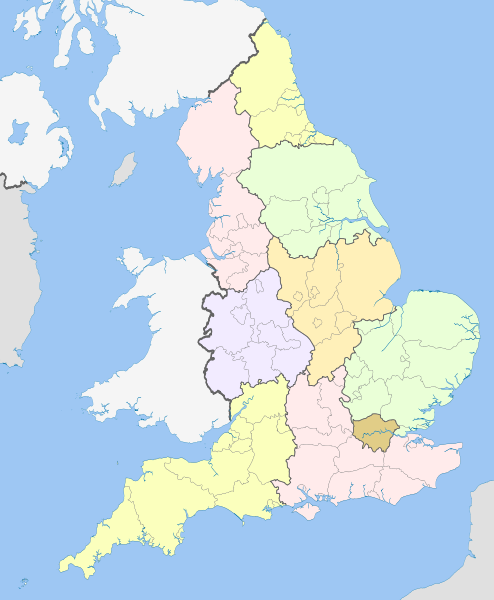
English: Map showing the Regions of England and the constituent metropolitan and non-metropolitan counties, in 2009.
Equirectangular map projection on WGS 84 datum, with N/S stretched 170% Geographic limits:
|
| Dagur | (UTC) |
| Kelda |
This file was derived from: English metropolitan and non-metropolitan counties 2010.svg:  |
| Høvundur |
|
| This is a retouched picture, which means that it has been digitally altered from its original version. Modifications: recoloured with some thicker boundary lines. The original can be viewed here: English metropolitan and non-metropolitan counties 2010.svg:
|
Lisensur
I, the copyright holder of this work, hereby publish it under the following licenses:
Henda fíla er gjørd atkomulig undir Creative Commons Navngev-Deil á sama hátt 3.0 Unported loyvinum.
Ognan: Nilfanion and Dr Greg
- Tú ert vælkomin til:
- at deila – at avrita, breiða út og senda verkið
- at remiksa – at tillaga ella broyta verkið
- Undir hesum treytum:
- ognan – Tú mást ognarskrivað verkið á ein slíkan hátt sum er útgreinaður av høvundanum ella lisenseigaranum (men ikki á nakran hátt ið kundi bent á at hesin hevur góðkent teg ella tína nýtslu av verkinum).
- deil undir somu treytum – Um tú broytir, evnar til ella byggir víðari á hetta verk, so kanst tú bert útgeva verkið undir somu ella líkandi lisensi sum hesin.

|
Loyvi verður givi at avrita, bera út og/ella broyta hetta skjal undir treytunum hjá GNU Free Documentation License, versión 1.2 ella einhvør seinni versjón ið er útgivin av Free Software Foundation; uttan nakað óbroytiligt brot, uttan forsíðutekst og uttan baksíðutekst. Eitt avrit av loyvinum er tikið við í brotinum ið nevnist GNU Free Documentation License. |
Tú kanst velja tann lisens ið tú ynskir.
Original upload log
This image is a derivative work of the following images:
- File:English_metropolitan_and_non-metropolitan_counties_2010.svg licensed with Cc-by-sa-3.0, GFDL
- 2010-11-23T22:01:59Z Nilfanion 1108x1345 (340057 Bytes) England only
- 2010-11-23T22:00:28Z Nilfanion 1108x1345 (376231 Bytes) {{Information |Description=Map showing the [[w:Metropolitan and non-metropolitan counties of England|Metropolitan and non-metropolitan counties of England]], in 2010. Equirectangular map projection on WGS 84 datum, with N/S
Uploaded with derivativeFX
Søgan hjá fíluni
Trýst á dato/tíð fyri at síggja fíluna, sum hon sá út tá.
| Dagur/Tíð | Lítil mynd | Dimensjónir | Brúkari | Viðmerking | |
|---|---|---|---|---|---|
| streymur | 21. apr 2012 kl. 20:04 | | 1.108 × 1.345 (365 KB) | Dr Greg | == {{int:filedesc}} == {{Information |Description={{en|Map showing the en:Regions of England and the constituent metropolitan and non-metropolitan counties, in 2009. Equirectangular m... |
Myndarslóðir
Hesar síður slóða til hesa mynd:
Alheims fílunýtsla
Aðrar wkiir brúka hesa fílu:
- Nýtsla á ban.wikipedia.org
- Nýtsla á bg.wikipedia.org
- Nýtsla á bs.wikipedia.org
- Nýtsla á en.wikipedia.org
- List of forests in the United Kingdom
- Subdivisions of England
- Regional assembly (England)
- Regional development agency
- Lists of schools in England
- User:Ric36/Sandbox
- Talk:Politics of England
- Template:England Labelled Map
- Health in England
- United Kingdom constitutional law
- Local authority leaders' board
- Regions of England
- Constitution of the United Kingdom
- Category:People by region in England
- Category:Cities in England by region
- Category:NUTS 1 statistical regions of England
- Devolution in the United Kingdom
- User talk:Iridescent/Archive 17
- Category:British school stubs
- User:Ric36/sandbox
- User:Bermicourt/Template:Lists of hills of English counties
- List of British regions by life expectancy
- Nýtsla á es.wikipedia.org
- Nýtsla á fr.wikipedia.org
- Nýtsla á hi.wikipedia.org
- Nýtsla á id.wikipedia.org
- Nýtsla á it.wikipedia.org
- Nýtsla á ja.wikipedia.org
- Nýtsla á ja.wikibooks.org
- Nýtsla á lv.wikipedia.org
- Nýtsla á mr.wikipedia.org
- Nýtsla á pl.wikipedia.org
- Nýtsla á pnb.wikipedia.org
- Nýtsla á pt.wikipedia.org
Vís meiri globala nýtslu av hesi fílu.