Mynd:British Isles.svg

Size of this PNG preview of this SVG file: 361 × 600 pixels. Aðrar upploysnir: 144 × 240 pixels | 289 × 480 pixels | 462 × 768 pixels | 616 × 1.024 pixels | 1.232 × 2.048 pixels | 1.300 × 2.160 pixels.
Upprunafíla (SVG fíle, nominelt 1.300 × 2.160 pixel, fíle stødd: 154 KB)
Samandráttur
| Frágreiðing |
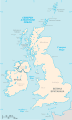
An SVG map of the British Isles, with the largest islands and archipelagos labelled. Always considered part of the British Isles
Sometimes considered part of the British Isles
Other lands |
| Kelda | Egið verk |
| Høvundur | Smurrayinchester |
| SVG genesis | This W3C-invalid map was created with unknown tool. This map is translated using SVG switch elements: all translations are stored in the same file. |
}
Lisensur
I, the copyright holder of this work, hereby publish it under the following license:

|
Loyvi verður givi at avrita, bera út og/ella broyta hetta skjal undir treytunum hjá GNU Free Documentation License, versión 1.2 ella einhvør seinni versjón ið er útgivin av Free Software Foundation; uttan nakað óbroytiligt brot, uttan forsíðutekst og uttan baksíðutekst. Eitt avrit av loyvinum er tikið við í brotinum ið nevnist GNU Free Documentation License. |
| Henda fíla er gjørd atkomulig undir Creative Commons Navngev-Deil á sama hátt 3.0 Unported loyvinum. | ||
| ||
| This licensing tag was added to this file as part of the GFDL licensing update. |
Derivative works
-
 македонски
 -
 Flag map (1801–1922)


derivative works
Derivative works of this file: British Isles mk.svg
Søgan hjá fíluni
Trýst á dato/tíð fyri at síggja fíluna, sum hon sá út tá.
| Dagur/Tíð | Lítil mynd | Dimensjónir | Brúkari | Viðmerking | |
|---|---|---|---|---|---|
| streymur | 10. feb 2019 kl. 15:33 | | 1.300 × 2.160 (154 KB) | MSG17 | Uploaded from SVG Translate. |
| 13. okt 2018 kl. 14:56 |  | 1.300 × 2.160 (141 KB) | Seb35 | small bug: translations have to be before the default text else the PNG rendering selects the default text | |
| 13. okt 2018 kl. 14:51 |  | 1.300 × 2.160 (141 KB) | Seb35 | added French translation | |
| 20. mai 2014 kl. 14:50 |  | 1.300 × 2.160 (135 KB) | NikNaks | More cleaning. File could still be a lot smaller than it currently is | |
| 20. mai 2014 kl. 03:02 |  | 1.300 × 2.160 (152 KB) | NikNaks | Malay translation | |
| 20. mai 2014 kl. 02:36 |  | 1.300 × 2.160 (148 KB) | NikNaks | Cleaning unfortunately lost detail. Will have to return to later | |
| 20. mai 2014 kl. 02:22 |  | 1.297 × 2.160 (37 KB) | NikNaks | Attempting to clean up the file before translation | |
| 20. aug 2006 kl. 12:37 |  | 1.297 × 2.160 (196 KB) | Smurrayinchester | An SVG map of the British Isles, with the largest islands and archipelagos labeled. {{legend|#fff0de|Always considered part of the British Isles|border=#ffffff}} {{legend|#ffb380|Sometimes considered part of the British Isles|border=#ffffff}} {{legend|#e |
Myndarslóðir
Ongar síður slóða til hesa myndina.
Alheims fílunýtsla
Aðrar wkiir brúka hesa fílu:
- Nýtsla á ar.wikipedia.org
- Nýtsla á az.wikipedia.org
- Nýtsla á be.wikipedia.org
- Nýtsla á bs.wikipedia.org
- Nýtsla á ceb.wikipedia.org
- Nýtsla á ckb.wikipedia.org
- Nýtsla á da.wikipedia.org
- Nýtsla á en.wikipedia.org
- Geography of the Isle of Man
- Burhou
- Talk:International Football Association Board
- Module:Location map/data/British Isles/doc
- List of offshore wind farms in the Irish Sea
- Siege of St Andrews Castle
- User:Malpass93/sandbox
- Module:Location map/data/British Isles
- 2014 Senior Open Championship
- 2017 Senior Open Championship
- 2018 Eisenhower Trophy
- User:Grover cleveland/History of the laws of the game/List of IFAB meetings
- User:Grover cleveland/English managers
- 2018 Espirito Santo Trophy
- 1965 European Amateur Team Championship
- 1975 European Amateur Team Championship
- 1981 European Amateur Team Championship
- 1989 European Amateur Team Championship
- 1997 European Amateur Team Championship
- 2005 European Amateur Team Championship
- 2007 European Amateur Team Championship
- 2009 European Amateur Team Championship
- 1971 European Ladies' Team Championship
- 1979 European Ladies' Team Championship
- 1987 European Ladies' Team Championship
- 1991 European Ladies' Team Championship
- 2013 European Ladies' Team Championship
- 2021 European Ladies' Team Championship
- 2022 European Amateur Team Championship
- 2022 European Ladies' Team Championship
- 2013 Senior Open Championship
- 2012 Senior Open Championship
- 2011 Senior Open Championship
- 2008 Senior Open Championship
- 2006 Senior Open Championship
- 2002 Senior British Open
- 2001 Senior British Open
- 2000 Senior British Open
- 2022 Senior Open Championship
- User:Erik Sergeant/sandbox 2
- 2023 Senior Open Championship
- Module:Location map/data/British Isles/sandbox
- Draft:2024 Monoposto Championship
Vís meiri globala nýtslu av hesi fílu.