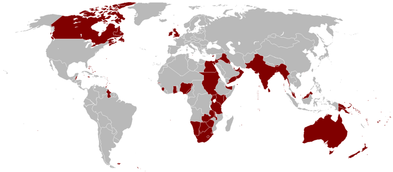
Mynd:British Empire 1921.png

Stødd av hesi forskoðan: 800 × 351 pixels. Aðrar upploysnir: 320 × 140 pixels | 640 × 281 pixels | 1.425 × 625 pixels.
Upprunafíla (1.425 × 625 pixel, stødd fílu: 58 KB, MIME-slag: image/png)
Søgan hjá fíluni
Trýst á dato/tíð fyri at síggja fíluna, sum hon sá út tá.
| Dagur/Tíð | Lítil mynd | Dimensjónir | Brúkari | Viðmerking | |
|---|---|---|---|---|---|
| streymur | 7. okt 2023 kl. 03:14 |  | 1.425 × 625 (58 KB) | Alanzx123 | added weihaiwei |
| 25. jul 2023 kl. 11:45 |  | 1.425 × 625 (40 KB) | Przemko1 | Bhutan, Sikkim british protectorates | |
| 31. okt 2021 kl. 08:02 |  | 1.425 × 625 (40 KB) | Randomastwritter | juba | |
| 14. mar 2019 kl. 22:05 |  | 1.425 × 625 (56 KB) | Horserice | Fixed Hong Kong. | |
| 5. jun 2017 kl. 16:27 |  | 1.425 × 625 (31 KB) | Maproom | Altered borders between Egypt, Libya and Sudan to agree with File:BlankMap-World-1921.png, which supposedly shows the correct borders as at 1921. | |
| 11. des 2015 kl. 19:44 |  | 1.425 × 625 (32 KB) | Braganza | Tibet existed until 1949 | |
| 3. sep 2015 kl. 19:35 |  | 1.425 × 625 (35 KB) | फ़िलप्रो | Fixed Nepal, Sikkim, and Bhutan. They were de facto princely states / protectorates of the British Empire. | |
| 26. mar 2015 kl. 21:02 |  | 1.425 × 625 (39 KB) | David C. S. | Ecudor in 1921 | |
| 7. mai 2011 kl. 19:00 |  | 1.425 × 625 (49 KB) | Quigley | Correct China's borders closer to what was internationally recognized at the time | |
| 13. okt 2010 kl. 01:33 |  | 1.425 × 625 (50 KB) | Vadac | Uploaded a clearer version with traditional British colour, added critical islands in Pacific and Caribbean and fixed the boarders of countries at the time such as Tuva among others |
Myndarslóðir
Hesar síður slóða til hesa mynd:
Alheims fílunýtsla
Aðrar wkiir brúka hesa fílu:
- Nýtsla á af.wikipedia.org
- Nýtsla á als.wikipedia.org
- Nýtsla á am.wikipedia.org
- Nýtsla á ar.wikipedia.org
- Nýtsla á ast.wikipedia.org
- Nýtsla á azb.wikipedia.org
- Nýtsla á az.wikipedia.org
- Nýtsla á bg.wikipedia.org
- Nýtsla á bn.wikipedia.org
- Nýtsla á br.wikipedia.org
- Nýtsla á ca.wikipedia.org
- Nýtsla á cs.wikipedia.org
- Nýtsla á da.wikipedia.org
- Nýtsla á de.wikipedia.org
- Nýtsla á el.wikipedia.org
- Nýtsla á en.wikipedia.org
Vís meiri globala nýtslu av hesi fílu.
