Mynd:Bjornoya Location Map-en.svg

Size of this PNG preview of this SVG file: 478 × 600 pixels. Aðrar upploysnir: 191 × 240 pixels | 383 × 480 pixels | 612 × 768 pixels | 816 × 1.024 pixels | 1.632 × 2.048 pixels | 1.010 × 1.267 pixels.
Upprunafíla (SVG fíle, nominelt 1.010 × 1.267 pixel, fíle stødd: 242 KB)
Samandráttur
| Frágreiðing |
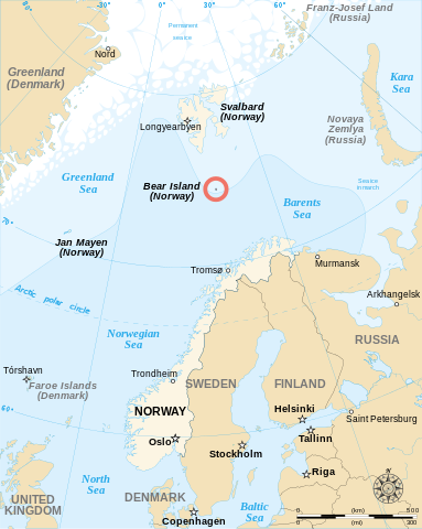
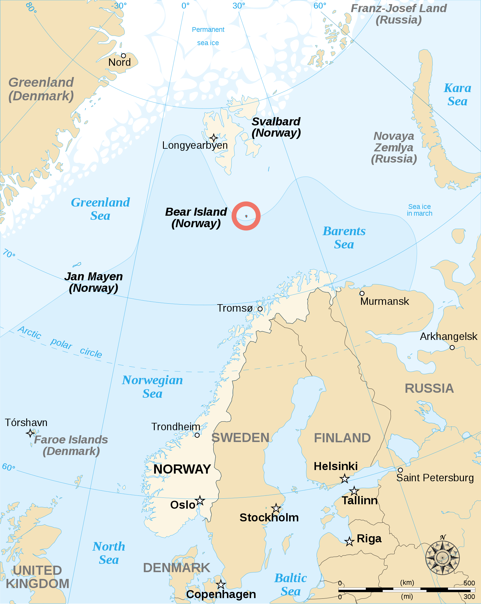
English: English map showing the location of Bear Island (Bjørnøya), a Norwegian island between Norway and Svalbard. Español: Carta en inglés con Bear Island (la isla del Oso). Français : Carte en anglais montrant l'emplacement de l'île aux Ours (Bjørnøya en norvégien), située entre la Norvège et l'archipel de Svalbard. |
||
| Dagur | |||
| Kelda | |||
| Høvundur | Sémhur | ||
| Other versions |
[]
|
||
| Ognan (required by the license) | © Sémhur / Wikimedia Commons / | ||
| SVG | W3C-validity not checked.
|
||
| Atelier graphique |


| Camera location | | View this and other nearby images on: OpenStreetMap |
|---|
Lisensur
I, the copyright holder of this work, hereby publish it under the following licenses:
| Copyleft: This work of art is free; you can redistribute it and/or modify it according to terms of the Free Art License. You will find a specimen of this license on the Copyleft Attitude site as well as on other sites. |
This file is licensed under the Creative Commons Attribution-Share Alike 4.0 International, 3.0 Unported, 2.5 Generic, 2.0 Generic and 1.0 Generic license.
- Tú ert vælkomin til:
- at deila – at avrita, breiða út og senda verkið
- at remiksa – at tillaga ella broyta verkið
- Undir hesum treytum:
- ognan – Tú mást ognarskrivað verkið á ein slíkan hátt sum er útgreinaður av høvundanum ella lisenseigaranum (men ikki á nakran hátt ið kundi bent á at hesin hevur góðkent teg ella tína nýtslu av verkinum).
- deil undir somu treytum – Um tú broytir, evnar til ella byggir víðari á hetta verk, so kanst tú bert útgeva verkið undir somu ella líkandi lisensi sum hesin.
Tú kanst velja tann lisens ið tú ynskir.
Søgan hjá fíluni
Trýst á dato/tíð fyri at síggja fíluna, sum hon sá út tá.
| Dagur/Tíð | Lítil mynd | Dimensjónir | Brúkari | Viðmerking | |
|---|---|---|---|---|---|
| streymur | 17. mai 2013 kl. 12:48 | | 1.010 × 1.267 (242 KB) | Sémhur | Correcting svg bugs |
| 2. nov 2007 kl. 14:00 |  | 1.010 × 1.267 (242 KB) | Sémhur | {{Information| Description= {{en}}English map showing the location of Bjørnøya (''Bear Island'' in English), an island between Norway and Svalbard. {{fr}}Carte en anglais montrant la localisation de l'île aux Ours (''Bjørnøya'' en Norvégien), situ� |
Myndarslóðir
Hesar síður slóða til hesa mynd:
Alheims fílunýtsla
Aðrar wkiir brúka hesa fílu:
- Nýtsla á ar.wikipedia.org
- Nýtsla á br.wikipedia.org
- Nýtsla á de.wikipedia.org
- Nýtsla á en.wikipedia.org
- Nýtsla á es.wikipedia.org
- Nýtsla á fa.wikipedia.org
- Nýtsla á fy.wikipedia.org
- Nýtsla á gl.wikipedia.org
- Nýtsla á hr.wikipedia.org
- Nýtsla á li.wikipedia.org
- Nýtsla á nl.wikipedia.org
- Nýtsla á nn.wikipedia.org
- Nýtsla á sk.wikipedia.org
- Nýtsla á sl.wikipedia.org
- Nýtsla á sr.wikipedia.org
- Nýtsla á sv.wikipedia.org
- Nýtsla á sw.wikipedia.org
- Nýtsla á uk.wikipedia.org
- Nýtsla á ur.wikipedia.org