Mynd:Antarctica.jpg

Stødd av hesi forskoðan: 486 × 599 pixels. Aðrar upploysnir: 195 × 240 pixels | 389 × 480 pixels | 623 × 768 pixels | 830 × 1.024 pixels | 1.661 × 2.048 pixels | 2.787 × 3.437 pixels.
Upprunafíla (2.787 × 3.437 pixel, stødd fílu: 2,06 MB, MIME-slag: image/jpeg)

|
File:Antarctica.CIA.svg is a vector version of this file. It should be used in place of this JPG file when not inferior.
File:Antarctica.jpg → File:Antarctica.CIA.svg
For more information, see Help:SVG. |
 |
Samandráttur
| Frágreiðing |
Español: Mapa de la Antártida |
| Kelda |
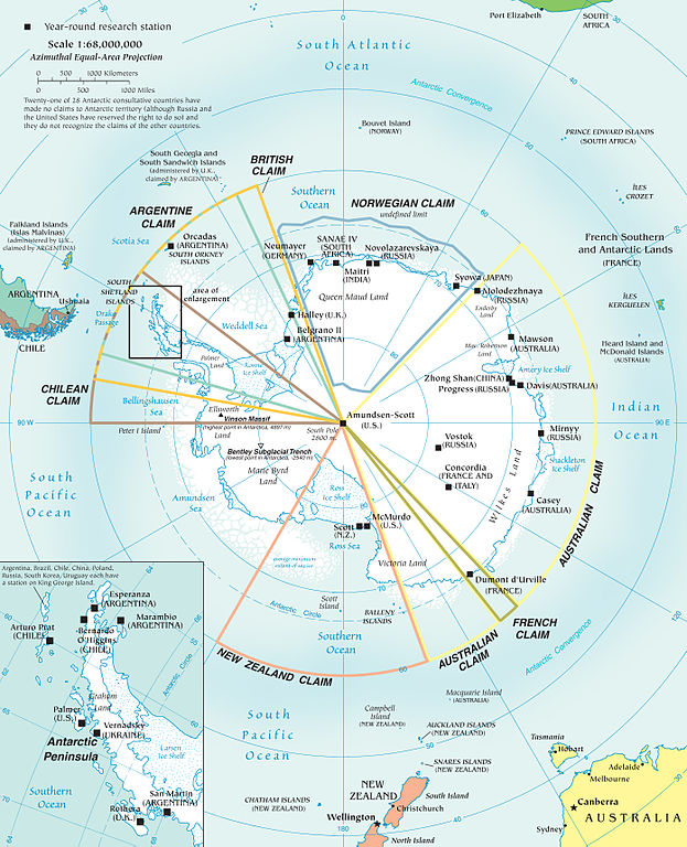
Map of Antarctica from en:Image:Antarctica.jpg Political map and research stations (2002) It is possible for an administrator to change the files with a delinker/linker tool? Manually i would need hours to make the changes.--Ras67 (talk) 20:40, 2 December 2010 (UTC) |
| Høvundur | |
| Other versions |
[]
|


Lisensur
This image is in the public domain because it contains materials that originally came from the United States Central Intelligence Agency's World Factbook.
|
 |
(Delete all revisions of this file) (cur) 16:45, 9 September 2005 . . Marknew (Talk) . . 1124x1400 (402970 bytes) (Higher quality and updated image (from PDF).)
(del) (rev) 02:39, 6 February 2005 . . Hfastedge (Talk) . . 990x1220 (210964 bytes) (Reverted to earlier revision)
(del) (rev) 01:58, 6 February 2005 . . DanQuixote (Talk) . . 519x659 (95411 bytes) (Reverted to earlier revision)
(del) (rev) 01:55, 6 February 2005 . . DanQuixote (Talk) . . 990x1220 (210964 bytes) (Antartica political map and research stations (2002))
(del) (rev) 11:49, 20 July 2002 . . . . 519x659 (95411 bytes)
Public domain, produced by the U.S. Central Intelligence Agency.[1] archive copy at the Wayback Machine
Larger file available at: The General Libraries, The University of Texas at Austin. [2]
![[2]](http://www.lib.utexas.edu/maps/islands_oceans_poles/antarctic_region_pol02.jpg)
Søgan hjá fíluni
Trýst á dato/tíð fyri at síggja fíluna, sum hon sá út tá.
| Dagur/Tíð | Lítil mynd | Dimensjónir | Brúkari | Viðmerking | |
|---|---|---|---|---|---|
| streymur | 3. des 2010 kl. 18:18 | | 2.787 × 3.437 (2,06 MB) | Ras67 | JPEG version of Antarctic_Region.png |
| 19. nov 2010 kl. 23:05 |  | 1.144 × 1.354 (1,16 MB) | P. S. Burton | top caption per WPMOS | |
| 8. jan 2006 kl. 17:58 |  | 1.124 × 1.400 (394 KB) | Marknew | Higher quality and updated image (from PDF). | |
| 18. jul 2005 kl. 00:49 |  | 990 × 1.220 (206 KB) | Thuresson | larger | |
| 31. jan 2005 kl. 21:15 |  | 519 × 659 (93 KB) | Leonard Vertighel | Map of Antarctica from en:Image:Antarctica.jpg |
Myndarslóðir
Hesar síður slóða til hesa mynd:
Alheims fílunýtsla
Aðrar wkiir brúka hesa fílu:
- Nýtsla á ar.wikipedia.org
- Nýtsla á cs.wikipedia.org
- Nýtsla á cv.wikipedia.org
- Nýtsla á da.wikipedia.org
- Nýtsla á en.wikipedia.org
- Nýtsla á es.wikipedia.org
- Nýtsla á et.wikipedia.org
- Nýtsla á eu.wikipedia.org
- Nýtsla á fa.wikipedia.org
- Nýtsla á fi.wikipedia.org
- Nýtsla á hr.wikipedia.org
- Nýtsla á hu.wikipedia.org
- Nýtsla á hy.wikipedia.org
- Nýtsla á id.wikipedia.org
- Nýtsla á it.wikipedia.org
- Nýtsla á jv.wikipedia.org
- Nýtsla á ko.wikipedia.org
- Nýtsla á lt.wikipedia.org
- Nýtsla á min.wiktionary.org
- Nýtsla á mk.wikipedia.org
- Nýtsla á mwl.wikipedia.org
- Nýtsla á no.wikipedia.org
- Nýtsla á qu.wikipedia.org
- Nýtsla á roa-tara.wikipedia.org
- Nýtsla á ru.wikipedia.org
- Nýtsla á scn.wikipedia.org
- Nýtsla á simple.wikipedia.org
- Nýtsla á sk.wikipedia.org
- Nýtsla á sl.wikipedia.org
- Nýtsla á sr.wikipedia.org
Vís meiri globala nýtslu av hesi fílu.