Mynd:Åland Political Map-sv.svg

Size of this PNG preview of this SVG file: 595 × 600 pixels. Aðrar upploysnir: 238 × 240 pixels | 476 × 480 pixels | 762 × 768 pixels | 1.016 × 1.024 pixels | 2.032 × 2.048 pixels | 996 × 1.004 pixels.
Upprunafíla (SVG fíle, nominelt 996 × 1.004 pixel, fíle stødd: 220 KB)
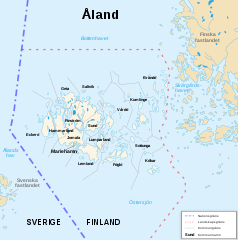
| Frágreiðing | Politisk karta över Åland |
| Dagur | (UTC) |
| Kelda | |
| Høvundur |
|
| Other versions |
|
| Camera location | | View this and other nearby images on: OpenStreetMap |
|---|
| This is a retouched picture, which means that it has been digitally altered from its original version. Modifications: Swedish translation. The original can be viewed here: Åland Political Map-en.svg:
|
I, the copyright holder of this work, hereby publish it under the following licenses:
This file is licensed under the Creative Commons Attribution-Share Alike 3.0 Unported, 2.5 Generic, 2.0 Generic and 1.0 Generic license.
- Tú ert vælkomin til:
- at deila – at avrita, breiða út og senda verkið
- at remiksa – at tillaga ella broyta verkið
- Undir hesum treytum:
- ognan – Tú mást ognarskrivað verkið á ein slíkan hátt sum er útgreinaður av høvundanum ella lisenseigaranum (men ikki á nakran hátt ið kundi bent á at hesin hevur góðkent teg ella tína nýtslu av verkinum).
- deil undir somu treytum – Um tú broytir, evnar til ella byggir víðari á hetta verk, so kanst tú bert útgeva verkið undir somu ella líkandi lisensi sum hesin.

|
Loyvi verður givi at avrita, bera út og/ella broyta hetta skjal undir treytunum hjá GNU Free Documentation License, versión 1.2 ella einhvør seinni versjón ið er útgivin av Free Software Foundation; uttan nakað óbroytiligt brot, uttan forsíðutekst og uttan baksíðutekst. Eitt avrit av loyvinum er tikið við í brotinum ið nevnist GNU Free Documentation License. |
Tú kanst velja tann lisens ið tú ynskir.
Original upload log
This image is a derivative work of the following images:
- File:Åland_Political_Map-en.svg licensed with Cc-by-sa-3.0,2.5,2.0,1.0, GFDL
- 2007-08-21T16:11:21Z Sémhur 996x1004 (223814 Bytes) {{Information |Description=Political map of the autonomous finnish province of Åland, in english. Shows the national, regional and municipal boundaries about Åland islands. |Source=Own work. Based on [[:Image:Alandmunicipal
Uploaded with derivativeFX
Søgan hjá fíluni
Trýst á dato/tíð fyri at síggja fíluna, sum hon sá út tá.
| Dagur/Tíð | Lítil mynd | Dimensjónir | Brúkari | Viðmerking | |
|---|---|---|---|---|---|
| streymur | 24. jan 2010 kl. 17:05 | | 996 × 1.004 (220 KB) | DJ Tricky | {{Information |Description=Politisk karta över Åland |Source=*File:Åland_Political_Map-en.svg |Date=2010-01-24 17:03 (UTC) |Author=*File:Åland_Political_Map-en.svg: Sémhur *derivative work: ~~~ |Permission=see below |othe |
Myndarslóðir
Hesar síður slóða til hesa mynd:
Alheims fílunýtsla
Aðrar wkiir brúka hesa fílu:
- Nýtsla á sv.wikipedia.org