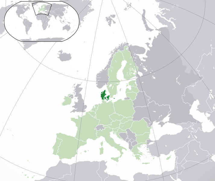
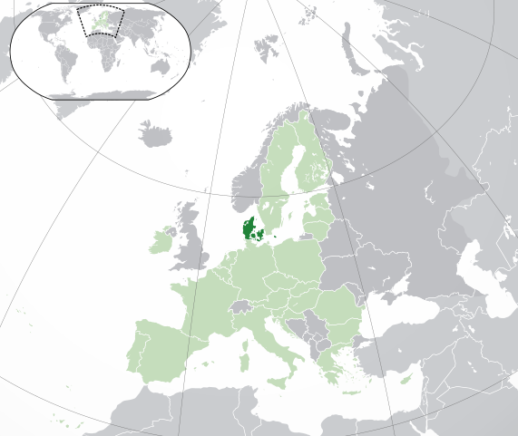
Mynd:EU-Denmark.svg

Size of this PNG preview of this SVG file: 713 × 600 pixels. Aðrar upploysnir: 285 × 240 pixels | 571 × 480 pixels | 913 × 768 pixels | 1.218 × 1.024 pixels | 2.435 × 2.048 pixels | 2.045 × 1.720 pixels.
Upprunafíla (SVG fíle, nominelt 2.045 × 1.720 pixel, fíle stødd: 7,33 MB)
Samandráttur
| Frágreiðing | |
| SVG genesis | |
| Dagur | |
| Kelda | Own work based on: Location European nation states.svg |
| Høvundur | NuclearVacuum |
| Other versions |
|
| SVG genesis |


Lisensur
I, the copyright holder of this work, hereby publish it under the following licenses:
Henda fíla er gjørd atkomulig undir Creative Commons Navngev-Deil á sama hátt 3.0 Unported loyvinum.
- Tú ert vælkomin til:
- at deila – at avrita, breiða út og senda verkið
- at remiksa – at tillaga ella broyta verkið
- Undir hesum treytum:
- ognan – Tú mást ognarskrivað verkið á ein slíkan hátt sum er útgreinaður av høvundanum ella lisenseigaranum (men ikki á nakran hátt ið kundi bent á at hesin hevur góðkent teg ella tína nýtslu av verkinum).
- deil undir somu treytum – Um tú broytir, evnar til ella byggir víðari á hetta verk, so kanst tú bert útgeva verkið undir somu ella líkandi lisensi sum hesin.

|
Loyvi verður givi at avrita, bera út og/ella broyta hetta skjal undir treytunum hjá GNU Free Documentation License, versión 1.2 ella einhvør seinni versjón ið er útgivin av Free Software Foundation; uttan nakað óbroytiligt brot, uttan forsíðutekst og uttan baksíðutekst. Eitt avrit av loyvinum er tikið við í brotinum ið nevnist GNU Free Documentation License. |
Tú kanst velja tann lisens ið tú ynskir.
Søgan hjá fíluni
Trýst á dato/tíð fyri at síggja fíluna, sum hon sá út tá.
| Dagur/Tíð | Lítil mynd | Dimensjónir | Brúkari | Viðmerking | |
|---|---|---|---|---|---|
| streymur | 1. feb 2020 kl. 04:49 | | 2.045 × 1.720 (7,33 MB) | Rob984 | UK and Gibraltar have left the EU. New base which includes all of Portugal's islands within frame, as well as Arctic Russian islands part of Europe. Also fixed Flevoland in the Netherlands. |
| 25. okt 2016 kl. 19:24 |  | 2.045 × 1.720 (7,32 MB) | Giorgi Balakhadze | fix | |
| 25. okt 2016 kl. 16:37 |  | 2.045 × 1.720 (7,33 MB) | Giorgi Balakhadze | Rv of sockpuppet and per COM:OVERWRITE | |
| 21. feb 2015 kl. 14:46 |  | 2.045 × 1.720 (7,38 MB) | Hazhk | Reverted to version as of 19:20, 19 November 2014 | |
| 21. feb 2015 kl. 14:05 |  | 2.045 × 1.720 (7,38 MB) | VS6507 | Spain. Greece. Slovakia. Cyprus. Romania VETO | |
| 19. nov 2014 kl. 19:20 |  | 2.045 × 1.720 (7,38 MB) | Leftcry | Reverted to version as of 19:36, 16 November 2014 Stop making such edits without consensus! Start a discussion on the talk page first! | |
| 19. nov 2014 kl. 11:09 |  | 2.045 × 1.720 (7,38 MB) | Mondolkiri1 | Correcting one island in Norway, therefore, also in the Nordic Council | |
| 19. nov 2014 kl. 10:30 |  | 2.045 × 1.720 (7,38 MB) | Mondolkiri1 | Corrections about some islands belonging to Norway, therefore, to the Nordic Council. | |
| 19. nov 2014 kl. 10:22 |  | 2.045 × 1.720 (7,38 MB) | Mondolkiri1 | Correction about some islands in Norway, therefore, in the Nordic Council | |
| 19. nov 2014 kl. 06:45 |  | 2.045 × 1.720 (7,38 MB) | Mondolkiri1 | Reverted to version as of 21:59, 18 November 2014 Sorry but this map is far more logic since Greenland and the Faroe Islands belong to Denmark and Nordic Council but not to EU! Don't be like an Eurocrat supremacist, please! |
Myndarslóðir
Hesar síður slóða til hesa mynd:
Alheims fílunýtsla
Aðrar wkiir brúka hesa fílu:
- Nýtsla á ady.wikipedia.org
- Nýtsla á af.wikipedia.org
- Nýtsla á ar.wikipedia.org
- الدنمارك
- بوابة:الدنمارك/واجهة
- بوابة:الدنمارك
- مستخدم:ElWaliElAlaoui/ملعب 8
- معاملة المثليين في الدنمارك
- مستخدم:جار الله/قائمة صور مقالات العلاقات الثنائية
- العلاقات الأنغولية الدنماركية
- العلاقات الدنماركية الكورية الجنوبية
- العلاقات الدنماركية الإريترية
- العلاقات الدنماركية السويسرية
- العلاقات الدنماركية الليختنشتانية
- العلاقات الدنماركية البوليفية
- العلاقات الدنماركية الموزمبيقية
- العلاقات الألبانية الدنماركية
- العلاقات الدنماركية البلجيكية
- العلاقات الدنماركية الإثيوبية
- العلاقات الدنماركية البيلاروسية
- العلاقات الدنماركية الطاجيكستانية
- العلاقات الدنماركية الرومانية
- العلاقات الأرجنتينية الدنماركية
- العلاقات الدنماركية الغامبية
- العلاقات الدنماركية القبرصية
- العلاقات الدنماركية السيراليونية
- العلاقات الدنماركية النيبالية
- العلاقات الدنماركية الليبيرية
- العلاقات التشيكية الدنماركية
- العلاقات الدنماركية الميانمارية
- العلاقات الدنماركية الكندية
- العلاقات الدنماركية الزيمبابوية
- العلاقات الدنماركية الإسرائيلية
- العلاقات الدنماركية البالاوية
- العلاقات الدنماركية المالية
- العلاقات الدنماركية النيجيرية
- العلاقات الدنماركية اليمنية
- العلاقات الدنماركية الفانواتية
- العلاقات الدنماركية الغابونية
- العلاقات الدنماركية البنمية
- العلاقات الدنماركية الكوبية
- العلاقات الدنماركية الجورجية
- العلاقات الدنماركية التونسية
- العلاقات الدنماركية الكورية الشمالية
- العلاقات الدنماركية الهندية
- العلاقات الدنماركية اليابانية
- العلاقات الدنماركية الإيطالية
- العلاقات الدنماركية الناوروية
- العلاقات الأسترالية الدنماركية
- العلاقات الدنماركية الزامبية
- العلاقات الدنماركية الفيجية
Vís meiri globala nýtslu av hesi fílu.